Toggle navigation
LMEC Home
Exhibitions
Georeferencing
Tools for Teachers
Collections
My Favorites
Sign Up / Log In
Search
Search the map portal
Map Collection
Map Collection
Map Sets
Search
Search
Search for
Search In
All Fields
Creator
Title
Subject
Place
Search All Digital Collections
Advanced Search
80 Results
My Search
Start Over
More Like
commonwealth:z603vp92z
Remove constraint More Like: commonwealth:z603vp92z
Filter your Search
Place
North and Central America
37
North America
35
United States
28
New Jersey
8
Northeastern United States
6
Middle Atlantic
5
Pennsylvania
5
Philadelphia
5
more
Place
»
Topic
North America--Maps--Early works to 1800
27
United States--Maps--Early works to 1800
14
Great Britain--Colonies--America--Maps--Early works to 1800
9
New Jersey--Maps--Early works to 1800
7
North America--Maps
7
Northeastern States--Maps--Early works to 1800
6
British--America--Maps--Early works to 1800
5
Pennsylvania--Maps--Early works to 1800
5
more
Topic
»
Date
Date range begin
–
Date range end
Current results range from
1746
to
1956
View distribution
Creator
Kitchin, Thomas, 1719-1784
6
Lodge, John, -1796
6
Gibson, J. (John), active 1750-1792
5
Hinton, John, -1781
5
Russell, John, active 1733-1795
5
Anville, Jean Baptiste Bourguignon d', 1697-1782
4
Jefferys, Thomas, -1771
4
Sayer, Robert, 1725-1794
4
more
Creator
»
Format
Maps/Atlases
80
Georeferenced
Yes
6
No
74
Collection
American Revolutionary War-Era Maps
77
New York Public Library Collection
77
Norman B. Leventhal Map & Education Center Collection
3
Available to use
Creative Commons license
77
No known restrictions
3
Search Constraints
Sort by relevance
relevance
title
date (asc)
date (desc)
Number of results to display per page
20 per page
10
per page
20
per page
50
per page
100
per page
View results as:
grid view
map view
Search Results
1.
Aaron Bohrod's America, its history
2.
Makers of the U.S.A. : a friendship map
3.
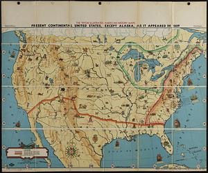
Present continental United States, except Alaska, as it appeared in 1609
4.
An accurate map of Canada, with the adjacent countries : exhibiting the late seat of war between the English & French in those...
5.
An accurate map of North America : Describing and distinguishing the British and Spanish dominions of this great continent;...
6.
An accurate map of the British, French & Spanish settlements in Nth. America and the West Indies : as stipulated by the...
7.
An Accurate map of the present seat of war between Great-Britain and her colonies in North America
8.
An accurate map of the United States of America : according to the Treaty of Peace of 1783
9.
Acurate charte von Nord-America : aus dem besten quellen
10.
America settentrionale divisa ne' suoi principali stati
11.
Amerique septentrionale divisée en ses principales parties
12.
Amerique septentrionale divisée en ses principales parties
13.
Canada, Louisiane et terres angloises
14.
Canada, Louisiane et terres angloises
15.
Canada, Louisiane et terres angloises
16.
Carta della Nuova Inghilterra, Nuova Yorc, e Pensilvania
17.
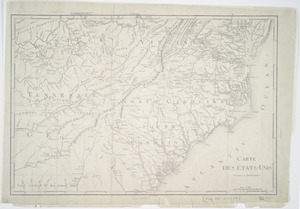
Carte des etats-unis : provinces méridionales
18.
Carte des Etats-unis : provinces septentrionales
19.
Carte du theatre de la guerre presente en Amerique
20.
Carte du theatre de la guerre presente en Amerique
‹ Prev
Next ›
1
2
3
4