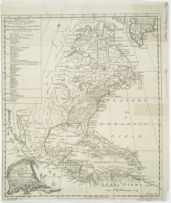
An accurate map of the British, French & Spanish settlements in Nth. America and the West Indies : as stipulated by the preliminary articles of peace sign'd at Fontainebleau by the ministers of Great Britain, France & Spain, Novr. 3d, 1762
This map is also available in American Revolutionary Geographies Online (ARGO), a collections portal especially built for material relating to the American Revolutionary War Era. Visit ARGO to learn more about this item and explore the historical geography of North America in the late eighteenth century.
Item Information
- Title:
- An accurate map of the British, French & Spanish settlements in Nth. America and the West Indies : as stipulated by the preliminary articles of peace sign'd at Fontainebleau by the ministers of Great Britain, France & Spain, Novr. 3d, 1762
- Title (uniform):
-
Universal museum (London, England : 1762)
- Creator:
- Gibson, John, active 1750-1787
- Contributor:
- Payne, John, -1787
- Name on Item:
-
J. Gibson sculp.
- Date:
-
[1762]
- Format:
-
Maps/Atlases
- Location:
- New York Public Library
- Collection (local):
-
Maps of North America
- Subjects:
-
North America--Maps--Early works to 1800
Great Britain--Colonies--America--Maps--Early works to 1800
Spain--Colonies--America--Maps--Early works to 1800
France--Colonies--America--Maps--Early works to 1800
- Places:
-
North America (area)
- Extent:
- 1 map ; 34 x 29 cm
- Terms of Use:
-
No known copyright restrictions.
This work is licensed for use under a Creative Commons Attribution Non-Commercial Share Alike License (CC BY-NC-SA).

- Publisher:
-
[London] :
[John Payne]
- Scale:
-
Scale [ca. 1:23,000,000]
- Language:
-
English
- Catalog Record:
-
https://digitalcollections.nypl.org/items/510d47db-b008-a3d9-e040-e00a18064a99
- Notes:
-
Relief shown pictorially.
Prime meridian: London.
From Universal museum or Gentleman's & ladies polite magazine, v. 1, December 1762.
Includes list of "The Settlements of the European nations in America ..."
- Notes (date):
-
This date is inferred.


