Toggle navigation
LMEC Home
Exhibitions
Georeferencing
Tools for Teachers
Collections
My Favorites
Sign Up / Log In
Search
Search the map portal
Map Collection
Map Collection
Map Sets
Search
Search
Search for
Search In
All Fields
Creator
Title
Subject
Place
Search All Digital Collections
Advanced Search
317 Results
My Search
Start Over
More Like
commonwealth:z603vj126
Remove constraint More Like: commonwealth:z603vj126
Filter your Search
Place
North and Central America
257
United States
163
Suffolk (county)
79
Boston
78
Canada
74
Massachusetts
32
Nova Scotia
23
Bunker Hill
21
more
Place
»
Topic
Manuscript maps--Early works to 1800
138
Coasts--Nova Scotia--Maps
62
Boston (Mass.)--History--Revolution, 1775-1783--Maps--Early works to 1800
45
Fortification--Massachusetts--Boston--Maps--Early works to 1800
30
Boston (Mass.)--Buildings, structures, etc--Maps, Manuscript--Early works to 1800
17
Bunker Hill, Battle of, Boston, Mass., 1775--Maps--Early works to 1800
16
Fortification--Massachusetts--Boston--Maps, Manuscript--Early works to 1800
11
Boston (Mass.)--History--Siege, 1775-1776--Maps--Early works to 1800
10
more
Topic
»
Date
Date range begin
–
Date range end
Current results range from
1700
to
1899
View distribution
Creator
Des Barres, Joseph F. W. (Joseph Frederick Wallet), 1722-1824
95
Page, Thomas Hyde, Sir, 1746-1821
16
Dumont de Montigny
14
Adlum, John, 1759-1836
9
Bingham, William, 1752-1804
9
Montrésor, John, 1736-1799
9
Aitken, Robert, 1735-1802
7
Faden, William, 1749-1836
6
more
Creator
»
Format
Maps/Atlases
313
Manuscripts
173
Drawings/Illustrations
3
Prints
1
Georeferenced
Yes
9
No
308
Collection
American Revolutionary War-Era Maps
311
Library of Congress Collection
228
Newberry Library Collection
39
Boston and New England Maps
33
Norman B. Leventhal Map & Education Center Collection
32
Maritime Charts and Atlases
17
Mapping Boston Collection
16
Richard H. Brown Revolutionary War Map Collection at Mount Vernon
16
more
Collection
»
Available to use
Creative Commons license
261
No known restrictions
17
Search Constraints
Sort by relevance
relevance
title
date (asc)
date (desc)
Number of results to display per page
20 per page
10
per page
20
per page
50
per page
100
per page
View results as:
grid view
map view
Search Results
121.
Plan de la Nlle. Orleans, ville capitalle de la Louissianne
122.
Plan de la ville de la Nouvelle Orleans : ou l'on à marqué l'augmentation des maisons qui sont baties depuis le 3. septembre...
123.
Plan de Missilimakinak avec la description de la route du Missisipi ; Idée de la situation du fort de Chambly, et des ses...
124.
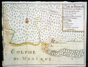
Plan de Pensacolle
125.
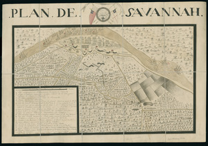
Plan de Savannah
126.
Plan du detroit de Belle Isle et du Golphe St. Laurent pour la coste du nord
127.
Plan du Fort des Yachoux, concession de Mgr. le duc de Belle Isle et associez, detruit 1729
128.
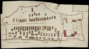
Plan du Fort du Sault de St. Louis et du village des sauvages Iroquois
129.
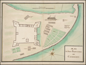
Plan du Fort Frontenac ou Cataracouy
130.
Plan du port et de la ville de Louisbourg : avec ses batteries et sa perspective, où est réprésenté les batteries faites...
131.
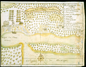
Plan du vieux Fort du Billoxi, 2 etablissement
132.
Plan of a rout undertaken in winter, Jany. 26th : from Quebec, the capital of Canada, to the frontier settlements of the...
133.
A plan of a survey made to explore the country for a road between Connecticut River & St. Francis
134.
A plan of Becket protracted by a scale of 120 rods to an inch
135.
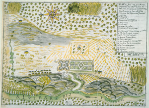
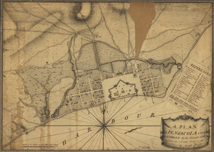
A plan of Pensacola and its environs in its present state : from an actual survey in 1778
136.
Plan of the attack on Fort William Henry and Ticonderoga : showing the road from Fort Edward, Montcalm's camp and wharf of...
137.
A Plan of the Battle of Bunker Hill
138.
Plan of the city intended for the permanent seat of the government of t[he] United States : projected agreeable to the...
139.
A plan of the division line between the provinces of New-York and Quebec : In the 45th degree of north latitude. Survey'd in...
140.
A plan of the harbour of Cape Lookout surveyed and sounded by His Majesty's sloop Viper
‹ Prev
Next ›
1
2
3
4
5
6
7
8
9
10
11
…
15
16


![Plan of the city intended for the permanent seat of the government of t[he] United States](https://bpldcassets.blob.core.windows.net/derivatives/images/commonwealth:q524nf917/image_thumbnail_300.jpg)