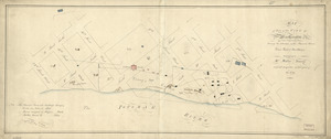
Plan of the city intended for the permanent seat of the government of t[he] United States : projected agreeable to the direction of the President of the United States, in pursuance of an act of Congress, passed on the sixteenth day of July, MDCCXC, "establishing the permanent seat on the bank of the Potowmac" : [Washington D.C.]
![Plan of the city intended for the permanent seat of the government of t[he] United States](https://bpldcassets.blob.core.windows.net/derivatives/images/commonwealth:q524nf917/image_access_800.jpg)
This map is also available in American Revolutionary Geographies Online (ARGO), a collections portal especially built for material relating to the American Revolutionary War Era. Visit ARGO to learn more about this item and explore the historical geography of North America in the late eighteenth century.
Item Information
- Title:
- Plan of the city intended for the permanent seat of the government of t[he] United States : projected agreeable to the direction of the President of the United States, in pursuance of an act of Congress, passed on the sixteenth day of July, MDCCXC, "establishing the permanent seat on the bank of the Potowmac" : [Washington D.C.]
- Creator:
- L'Enfant, Pierre Charles, 1754-1825
- Contributor:
- United States. Commissioner of Public Buildings
- Name on Item:
-
by Peter Charles L'Enfant
- Date:
-
[1791]
- Format:
-
Maps/Atlases
Manuscripts
- Location:
- Library of Congress Geography and Map Division
- Collection (local):
-
Library of Congress Collection
- Subjects:
-
Washington (D.C.)--Maps, Manuscript--Early works to 1800
Manuscript maps--Early works to 1800
- Places:
-
Washington
- Extent:
- 1 map : ms., col. ; 70 x 81 cm., on sheet 73 x 104 cm.
- Terms of Use:
-
No known copyright restrictions.
This work is licensed for use under a Creative Commons Attribution Non-Commercial Share Alike License (CC BY-NC-SA).

- Scale:
-
Scale [ca. 1:15,840]
- Language:
-
English
- Catalog Record:
-
https://lccn.loc.gov/88694205
- Notes:
-
The earliest extant plan of Washington D.C., known as "The L'Enfant Plan."
At upper right: Office, Commissioner of Public Buildings, D.C.
Dark and light inks, watercolors, and lead pencil annotations (some erased).
Watermarks: GR, TB, [crown over fleur-de-lis in shield].
Originally drawn on 2 sheets.
Brittle, torn, faded, missing edge and interior sections, varnished, darkened, and housed between sheets of glass in wooden frame.
Includes text, notes, and index of "References."
At lower right: N.I.
- Notes (date):
-
This date is inferred.
- Notes (citation):
-
Quarterly journal of the Library of Congress, v. 36, no. 3, summer 1979
- Identifier:
-
ct002167b


 IIIF Manifest