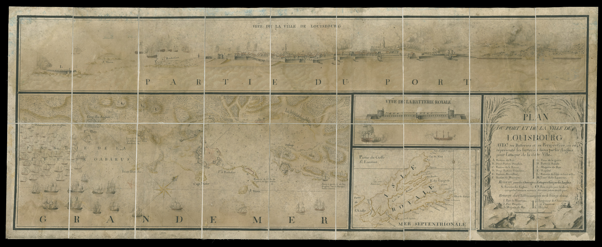
Plan du port et de la ville de Louisbourg : avec ses batteries et sa perspective, où est réprésenté les batteries faites par les anglais pour l'attaque de la ditte ville
This map is also available in American Revolutionary Geographies Online (ARGO), a collections portal especially built for material relating to the American Revolutionary War Era. Visit ARGO to learn more about this item and explore the historical geography of North America in the late eighteenth century.
Item Information
- Title:
- Plan du port et de la ville de Louisbourg : avec ses batteries et sa perspective, où est réprésenté les batteries faites par les anglais pour l'attaque de la ditte ville
- Description:
-
Details 1745 siege and capture of French fort at Louisbourg on Nova Scotia by British forces comprised of New England troops. Keyed to references A-O and 1-5.
- Date:
-
[1745?]
- Format:
-
Maps/Atlases
Manuscripts
- Location:
- Newberry Library
- Collection (local):
-
Everett D. Graff Collection of Western Americana
- Subjects:
-
Fortification--Nova Scotia--Louisbourg--Manuscripts--Early works to 1800
Manuscript maps--Early works to 1800
Louisbourg (N.S.)--Maps--Early works to 1800
Louisbourg (N.S.)--Pictorial works--Early works to 1800
Cape Breton Island (N.S.)--Maps--Early works to 1800
Louisbourg (N.S.)--History--Siege, 1745--Maps--Early works to 1800
United States--History--King George's War, 1744-1748--Campaigns--Maps--Early works to 1800
- Places:
-
CanadaNova Scotia (province)Cape Breton Island (island)
CanadaNova Scotia (province)Louisbourg
- Extent:
- 1 ms. map : hand col. ; 312 x 766 mm. on sheet 551 x 1,403 mm.
- Terms of Use:
-
No known copyright restrictions.
Contact host institution for more information.
- Scale:
-
Scale [ca. 1:11,300]
- Language:
-
French
- Catalog Record:
-
https://i-share-nby.primo.exlibrisgroup.com/permalink/01CARLI_NBY/i5mcb2/alma991482488805867
- Notes:
-
Includes inset map (187 x 276 mm.): Isle royale; and 2 views (171 x 1,321 mm. and 114 x 272 mm.): Veüe de la ville de Loüisbourg, and, Veüe de la batterie royale.
Oriented to the northeast.
Pen-and-ink and watercolor (green, yellow, red, gray); sectioned and mounted on cloth.
Related to ms. in the Archives du Service Hydrographique (Paris), no. SHA 131-11-6. Reproduced as plate 5 in Baker, Raymond F. A campaign of amateurs : the siege of Louisbourg, 1745 (Canadian historic sites ; no. 18) Ottawa : National Historic Parks and Sites Branch, 1978.
- Call #:
-
Ayer MS map 196


