Toggle navigation
LMEC Home
Exhibitions
Georeferencing
Tools for Teachers
Collections
My Favorites
Sign Up / Log In
Search
Search the map portal
Map Collection
Map Collection
Map Sets
Search
Search
Search for
Search In
All Fields
Creator
Title
Subject
Place
Search All Digital Collections
Advanced Search
497 Results
My Search
Start Over
More Like
commonwealth:z603vg175
Remove constraint More Like: commonwealth:z603vg175
Filter your Search
Place
North and Central America
459
United States
404
Canada
36
Louisiana
36
North America
29
Florida
24
West Indies
24
New York
12
more
Place
»
Topic
United States--Maps
327
Elections--United States--Maps
36
Louisiana--Maps
36
Railroads--United States--Maps
34
North America--Maps
28
Canada--Maps
25
Florida--Maps
25
West Indies--Maps
25
more
Topic
»
Date
Date range begin
–
Date range end
Current results range from
1749
to
2023
View distribution
Creator
Paullin, Charles Oscar, 1868 or 1869-1944
70
Wright, John Kirtland, 1891-1969
70
Geological Survey (U.S.)
26
Reid, John, 1764?-1828
11
Farwell, John Whittemore, 1843-1929
9
United States. Post Office Dept
9
Carleton, Osgood, 1742-1816
8
Kitchin, Thomas, 1719-1784
8
more
Creator
»
Format
Maps/Atlases
495
Manuscripts
13
Prints
2
Books
1
Objects/Artifacts
1
Posters
1
Georeferenced
Yes
89
No
408
Collection
Norman B. Leventhal Map & Education Center Collection
328
American Revolutionary War-Era Maps
168
American Antiquarian Society Collection
138
William L. Clements Library Collection
20
MacLean Collection Map Library
10
David Judkins Weaver Papers
2
Mapping Boston Collection
2
Applied Geographics, Inc. Records
1
more
Collection
»
Available to use
No known restrictions
252
Creative Commons license
7
Search Constraints
Sort by relevance
relevance
title
date (asc)
date (desc)
Number of results to display per page
20 per page
10
per page
20
per page
50
per page
100
per page
View results as:
grid view
map view
Search Results
181.
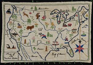
Map of the United States
182.
Map of the United States
183.
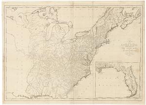
A map of the United States
184.
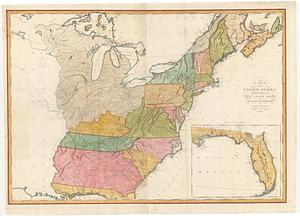
A map of the United States : compiled chiefly from the state maps, and other authentic information
185.
Map of the United States
186.
Map of the United States
187.
A map of the United States and Canada, New-Scotland, New-Brunswick and New-Foundland = Carte des Etats-Unis avec le Canada, la...
188.
Map of the United States and territories, showing the extent of public surveys and other details constructed from the plats and...
189.
Map of the United States and territories with adjacent parts of Canada and Mexico, also part of the West India Islands :...
190.
Map of the United States, British & Central America : from state documents & unpublished materials
191.
A map of the United States: compiled chiefly from the state maps, and other authentic information
192.
A map of the United States: compiled chiefly from the state maps, and other authentic information
193.
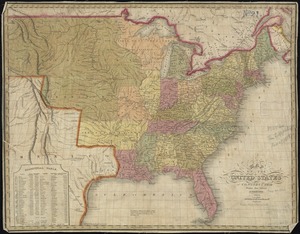
Map of the United States, constructed from the latest authorities
194.
Map of the United States, constructed from the latest authorities
195.
A map of the United States east of the Mississippi River in which the land ceded by the Treaty of Paris is divided by parallels...
196.
A map of the United States east of the Mississippi River in which the land ceded by the Treaty of Paris is divided by parallels...
197.
Map of the United States, exhibiting the post-roads, the situations, connections & distances of the post-offices stage roads,...
198.
Map of the United States exhibiting the several collection districts
199.
Map of the United States, from the latest surveys : with the heights of mountains and length of the principle rivers
200.
A map of the United States, from the latest surveys : with the height of mountains and length of the principal rivers
‹ Prev
Next ›
1
2
…
6
7
8
9
10
11
12
13
14
…
24
25