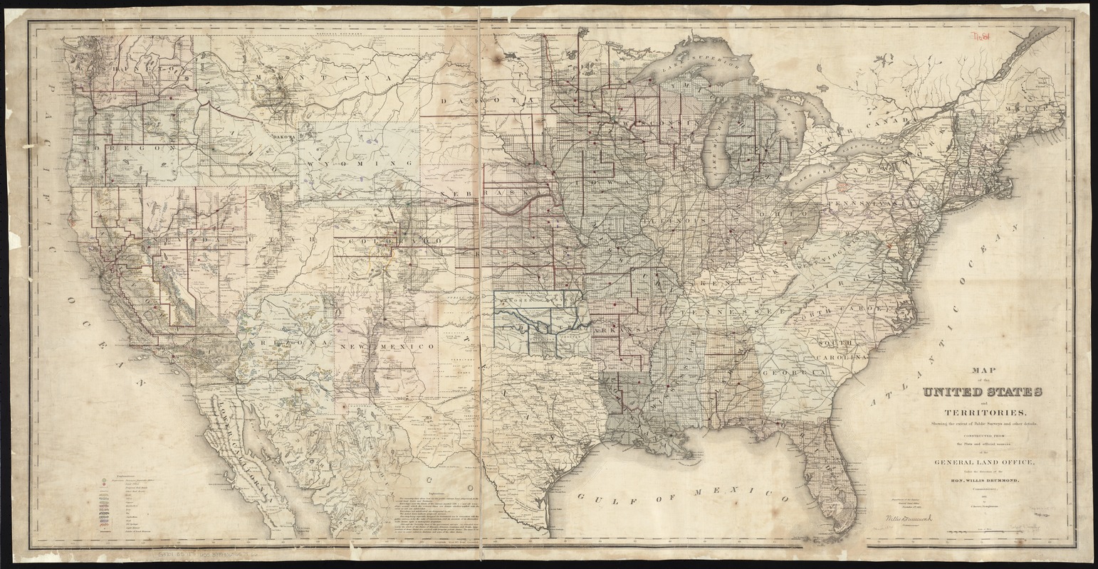
Map of the United States and territories, showing the extent of public surveys and other details constructed from the plats and official sources of the General Land Office
Item Information
- Title:
- Map of the United States and territories, showing the extent of public surveys and other details constructed from the plats and official sources of the General Land Office
- Description:
-
America Transformed: Published shortly after the American Civil War, this map depicts a reunited nation, but it also provides an inventory of land and mineral resources. While the General Land Office, the federal agency responsible for surveying and selling public lands, produced this map as a yearly update of its activities, it also promoted further expansion of western settlement. The square grid pattern appearing in most states west of the Appalachian Mountains indicates the extent of public land or township surveys. Color coding identifies the location of mineral resources. Reflecting the efforts to unify the nation after the Civil War, this map marks the route of the first transcontinental railroad.
- Creator:
- United States. General Land Office
- Name on Item:
-
under the direction of Willis Drummond, Commissioner, by C. Roeser, draughtsman.
- Date:
-
1871
- Format:
-
Maps/Atlases
- Location:
-
Boston Public Library
Norman B. Leventhal Map & Education Center - Collection (local):
-
Norman B. Leventhal Map & Education Center Collection
- Subjects:
-
Mines and mineral resources--United States--Maps
United States--Maps
- Places:
-
United States
- Extent:
- 1 map on 2 sheets : hand col., assembled ; 69 x 138 cm.
- Terms of Use:
-
No known copyright restrictions.
No known restrictions on use.
- Publisher:
-
[Washington, D.C.] :
General Land Office
- Scale:
-
Scale [ca. 1:3,800,000]
- Language:
-
English
- Notes:
-
Relief shown by hachures.
Also shows mine and mineral resources, Land Office locations, and railroads.
"November 1st, 1871."
Includes notes.
- Notes (exhibitions):
-
Exhibited: "America transformed. Part 1: the United States expands westward," organized by the Norman B. Leventhal Map & Education Center at the Boston Public Library, 2019.
- Identifier:
-
06_01_008798
- Call #:
-
G3701.B5 1871 .U55
- Barcode:
-
39999065657866