Toggle navigation
LMEC Home
Exhibitions
Georeferencing
Tools for Teachers
Collections
My Favorites
Sign Up / Log In
Search
Search the map portal
Map Collection
Map Collection
Map Sets
Search
Search
Search for
Search In
All Fields
Creator
Title
Subject
Place
Search All Digital Collections
Advanced Search
8649 Results
My Search
Start Over
More Like
commonwealth:x633f968t
Remove constraint More Like: commonwealth:x633f968t
Filter your Search
Place
North and Central America
5,887
United States
4,805
Massachusetts
2,068
Europe
1,392
Suffolk (county)
1,041
Boston
1,014
Canada
449
Asia
437
more
Place
»
Topic
Boston (Mass.)--Maps
582
United States--Maps
279
Real property--Massachusetts--Boston--Maps
175
Massachusetts--Maps
161
Landowners--Massachusetts--Boston--Maps
133
North America--Maps--Early works to 1800
104
New England--Maps
101
Europe--Maps
79
more
Topic
»
Date
Date range begin
–
Date range end
Current results range from
1482
to
2023
View distribution
Creator
United States. Hydrographic Office
595
O.H. Bailey & Co
148
Des Barres, Joseph F. W. (Joseph Frederick Wallet), 1722-1824
123
United States. Post Office Dept
120
Ptolemy, 2nd cent
100
Walling, Henry Francis, 1825-1888
94
Geological Survey (U.S.)
86
Jefferys, Thomas, -1771
86
more
Creator
»
Format
Maps/Atlases
8,589
Manuscripts
215
Prints
56
Books
36
Objects/Artifacts
10
Drawings/Illustrations
8
Posters
5
Georeferenced
Yes
869
No
7,780
Collection
Norman B. Leventhal Map & Education Center Collection
8,646
Boston and New England Maps
2,221
Urban Maps
1,992
Maritime Charts and Atlases
1,082
American Revolutionary War-Era Maps
616
Boston Redevelopment Authority Collection
87
Sidney R. Knafel Map Collection at Phillips Academy
2
Richard H. Brown Revolutionary War Map Collection at Mount Vernon
1
Available to use
No known restrictions
8,504
Creative Commons license
48
Search Constraints
Sort by relevance
relevance
title
date (asc)
date (desc)
Number of results to display per page
20 per page
10
per page
20
per page
50
per page
100
per page
View results as:
grid view
map view
Search Results
1.
Mare del Nord
2.
Pascaerte van Westindien de Vaste Kusten en de Eylanden
3.
West-Indische paskaert : waer in de graden der breedde over weder zyden vande middellyn wassende soo vergroten dat die...
4.
A chart of the coast of Barbaria with the western, Canaria, & Cape de Verd, isles
5.
Coste occidentale d'Afrique, depuis le Détroit de Gibraltar jusqu' au XIe dégré de latitude septentrionale : tirée de la...
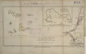
6.
A map of the Cape de Verd Islands with the adjacent coast of Africa, the settlements of Senegal, Gambia and Goree, also a plan...
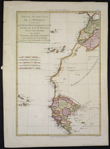
7.
Partie occidentale de L'Afrique, contenant les pays et etats voisins de la côte, entre le Cap St. Vincent et le Cap Tagrin :...
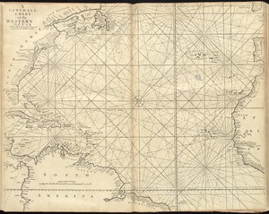
8.
A generall chart of the western ocean
9.
A new generall chart for the West Indies of E. Wrights projection vul. Mercators chart
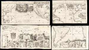
10.
Carte de la Mer du Sud et des costes d'Amerique et d'Asie situées sur cette mer : Carte de la Mer du Nord et des costes...
11.
Chart of the Atlantic Ocean, with the British, French, & Spanish settlements in North America, and the West Indies : as also on...
12.
Chart of the Atlantic Ocean, with the British, French, & Spanish settlements in North America, and the West Indies : as also on...
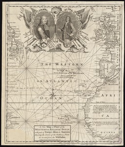
13.
A new chart of the vast Atlantic or Western Ocean including the sea coast of Europe, Africa, America, and the West India...
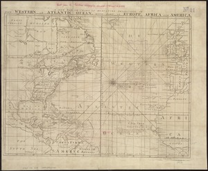
14.
A new map or chart in Mercators projection, of the Western or Atlantic Ocean, with part of Europe, Africa and America
15.
A new map or chart of the Western or Atlantic Ocean, with part of Europe Africa & America : showing the course of galleons,...
16.
Oceani occidetalis seu terre nove tabula
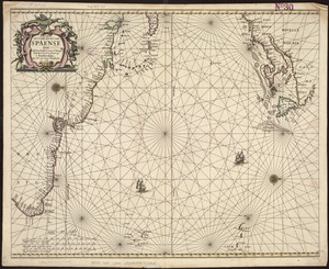
17.
Pascaerte van 't westelyckste deel vande Spaense Zee, tuschen Brasil, de zoute en Vlaemse eylanded, en voorwestwart
18.
Atlantic Ocean
19.
Chart of the Atlantic Ocean, with the British, French, & Spanish settlements in North America, and the West Indies : as also on...
20.
Oceani occidetalis seu terre nove tabula
‹ Prev
Next ›
1
2
3
4
5
…
432
433