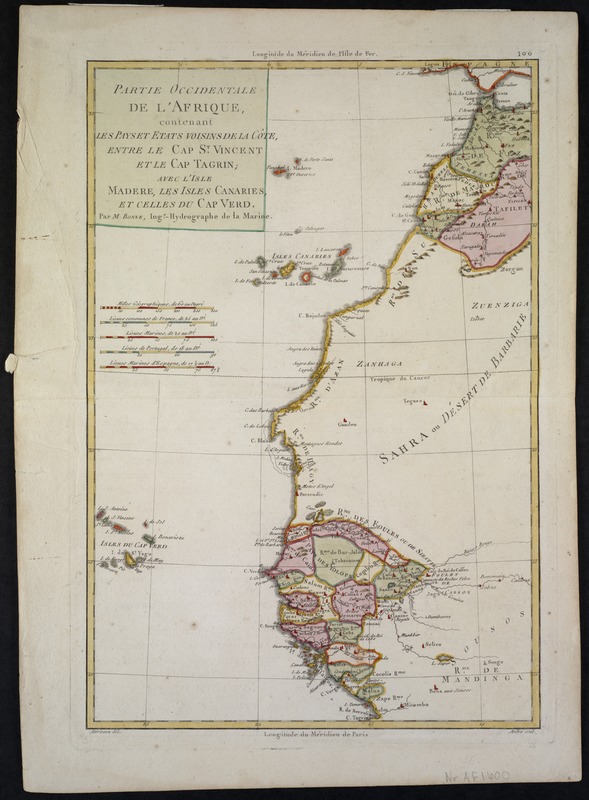
Partie occidentale de L'Afrique, contenant les pays et etats voisins de la côte, entre le Cap St. Vincent et le Cap Tagrin : avec L'Isle Madere, Les Isles Canaries, et celles du Cap Verd
Item Information
- Title:
- Partie occidentale de L'Afrique, contenant les pays et etats voisins de la côte, entre le Cap St. Vincent et le Cap Tagrin : avec L'Isle Madere, Les Isles Canaries, et celles du Cap Verd
- Description:
-
Published by the French Depot de la Marine, this map of northwestern Africa depicts the settled tribal areas located north and south of the Sahara Desert. These brightly colored jurisdictions provide a stark contrast to the desolation of the desert itself, which dominates the center of the map. The coast line shown here runs from the Straits of Gibraltar in the north to Cape Tagrin and the Sierra Leone River in the south. The Cape Verde Islands appear at the lower left.
- Creator:
- Bonne, Rigobert, 1727-1794
- Name on Item:
-
par Mr. Bonne ; Hérisson del. ; André scul.
- Date:
-
1770
- Format:
-
Maps/Atlases
- Location:
-
Boston Public Library
Norman B. Leventhal Map & Education Center - Collection (local):
-
Norman B. Leventhal Map & Education Center Collection
- Subjects:
-
Coasts--Africa--Maps--Early works to 1800
Atlantic Coast (Africa)--Maps--Early works to 1800
Cape Verde--Maps--Early works to 1800
Canary Islands--Maps--Early works to 1800
- Places:
-
Africa
Cape Verde
SpainCanary Islands (island)
Africa
- Extent:
- 1 map : col. ; 26 x 36 cm.
- Terms of Use:
-
No known copyright restrictions.
No known restrictions on use.
- Publisher:
-
Paris :
[s.n.]
- Scale:
-
Scale not given.
- Language:
-
French
- Notes:
-
Relief shown pictorially.
Exhibited in “Faces and Places,” at the Boston Public Library, Boston, MA, October 2003 - September 2004. MB (BRL)
- Identifier:
-
06_01_000064
- Call #:
-
G8737.C6 1770 .B6
- Barcode:
-
39999052507389