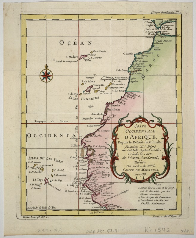
Coste occidentale d'Afrique, depuis le Détroit de Gibraltar jusqu' au XIe dégré de latitude septentrionale : tirée de la carte de l'Océan Occidental
Item Information
- Title:
- Coste occidentale d'Afrique, depuis le Détroit de Gibraltar jusqu' au XIe dégré de latitude septentrionale : tirée de la carte de l'Océan Occidental
- Description:
-
This map of the west coast of Africa was first engraved in 1738 by order of Jean-Frederic Phelypeaux, Count of Maurepas and Secretary of State under the French King Louis XVI. The map is a microcosm of African colonialism during this period; the Cape Verde islands were in the hands of the Portuguese, the Canaries were occupied by the Spanish, the French controlled Senegal on the mainland, while Morocco, incredibly, remained independent. With much at stake for the occupying power, accurate maps were of critical importance for navigators and politicians alike. The accurate placement of islands was especially important for navigation -- hundreds of ships had been lost on the rocks or islands that appeared where the ship's navigator did not expect them to be. Hence, the emphasis in this map on accurate longitude of capes and islands, and the legend in the lower right corner explaining the method used for determining latitude and longitude for particularly dangerous locations.
- Creator:
- Bellin, Jacques Nicolas, 1703-1772
- Name on Item:
-
publiée par ordre de M.gr. le Comte de aurepas ; par N. Bellin.
- Date:
-
1738
- Format:
-
Maps/Atlases
- Location:
-
Boston Public Library
Norman B. Leventhal Map & Education Center - Collection (local):
-
Norman B. Leventhal Map & Education Center Collection
- Subjects:
-
Africa, West--Maps--Early works to 1800
Atlantic Coast (Africa)--Maps--Early works to 1800
- Places:
-
West Africa (area)
- Extent:
- 1 map : col. ; 20 x 25 cm.
- Terms of Use:
-
No known copyright restrictions.
No known restrictions on use.
- Publisher:
-
Paris :
s.n.
- Scale:
-
Scale not given.
- Language:
-
French
- Notes:
-
Relief shown pictorially.
Exhibited in “Faces and Places,” at the Boston Public Library, Boston, MA, October 2003 - September 2004. MB (BRL)
- Identifier:
-
05_04_000149
- Call #:
-
G8735 1738 .B45
- Barcode:
-
39999052509666