Toggle navigation
LMEC Home
Exhibitions
Georeferencing
Tools for Teachers
Collections
My Favorites
Sign Up / Log In
Search
Search the map portal
Map Collection
Map Collection
Map Sets
Search
Search
Search for
Search In
All Fields
Creator
Title
Subject
Place
Search All Digital Collections
Advanced Search
8945 Results
My Search
Start Over
More Like
commonwealth:wd3768095
Remove constraint More Like: commonwealth:wd3768095
Filter your Search
Place
North and Central America
6,176
United States
5,080
Massachusetts
2,216
Europe
1,396
Suffolk (county)
1,210
Boston
1,183
Canada
450
Asia
438
more
Place
»
Topic
Boston (Mass.)--Maps
752
United States--Maps
282
Massachusetts--Maps
235
Real property--Massachusetts--Boston--Maps
195
City planning--Massachusetts--Boston--Maps
158
Landowners--Massachusetts--Boston--Maps
142
New England--Maps
106
North America--Maps--Early works to 1800
103
more
Topic
»
Date
Date range begin
–
Date range end
Current results range from
1482
to
2023
View distribution
Creator
United States. Hydrographic Office
595
Boston Redevelopment Authority
162
O.H. Bailey & Co
148
Des Barres, Joseph F. W. (Joseph Frederick Wallet), 1722-1824
124
United States. Post Office Dept
120
Ptolemy, 2nd cent
100
Walling, Henry Francis, 1825-1888
95
Geological Survey (U.S.)
92
more
Creator
»
Format
Maps/Atlases
8,884
Manuscripts
217
Prints
56
Books
36
Objects/Artifacts
10
Drawings/Illustrations
8
Posters
6
Ephemera
1
Georeferenced
Yes
894
No
8,051
Collection
Norman B. Leventhal Map & Education Center Collection
8,772
Boston and New England Maps
2,411
Urban Maps
2,143
Maritime Charts and Atlases
1,087
American Revolutionary War-Era Maps
662
Boston Redevelopment Authority Collection
195
Mapping Boston Collection
29
William L. Clements Library Collection
23
more
Collection
»
Available to use
No known restrictions
8,708
Creative Commons license
80
Search Constraints
Sort by relevance
relevance
title
date (asc)
date (desc)
Number of results to display per page
20 per page
10
per page
20
per page
50
per page
100
per page
View results as:
grid view
map view
Search Results
6981.
Port Jackson
6982.
Port Mills : Port Mansfield ; Gambier Harbour
6983.
Port Mills : Port Mansfield ; Gambier Harbour
6984.
Port of Manchester
6985.
The port of Salem, Massachusetts
6986.
Port Orchard, Puget Sound, Washington Ter.
6987.
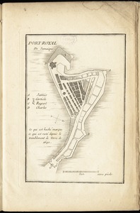
Port Royal appellé aujourd. par les Anglois Annapolis Royal
6988.
Port Royal in South Carolina : taken from surveys deposited at the Plantation Office
6989.
[Port Shediack and Cocagne]
6990.
Portage County, Wis.
6991.
Portage Lake and River with part of Keweenaw Bay
6992.
Portion of the copper district, Michigan, Lake Superior
6993.
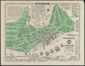
Portland also called Falmouth first settled 1632 chartered as a city 1832
6994.
Portland, Penn
6995.
Porto Rico and Virgin Isles : Haiti, Hispaniola or St. Domingo
6996.
Portolan atlas
6997.
Porto-Rico showing road work, light houses, rail roads, towns and coast line
6998.
Port-Royal de Jamaique
6999.
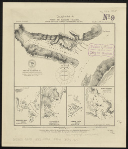
Ports in Barbara Channel : from British surveys corrected to 1877
7000.
Ports in the Philippine Islands
‹ Prev
Next ›
1
2
…
346
347
348
349
350
351
352
353
354
…
447
448


![[Port Shediack and Cocagne]](https://bpldcassets.blob.core.windows.net/derivatives/images/commonwealth:ws859h35r/image_thumbnail_300.jpg)