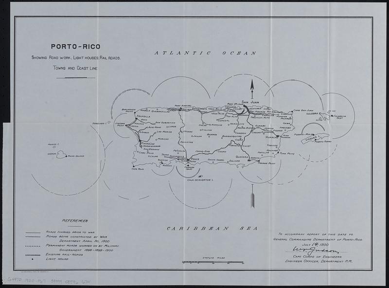
Porto-Rico showing road work, light houses, rail roads, towns and coast line
Item Information
- Title:
- Porto-Rico showing road work, light houses, rail roads, towns and coast line
- Contributor:
- Puerto Rico. Military Governor
- Contributor:
- United States. Division of Insular Affairs
- Date:
-
[1902]
- Format:
-
Maps/Atlases
- Location:
-
Boston Public Library
Norman B. Leventhal Map & Education Center - Collection (local):
-
Norman B. Leventhal Map & Education Center Collection
- Subjects:
-
Puerto Rico--Maps
Lighthouses--Puerto Rico--Maps
Railroads--Puerto Rico--Maps
Roads--Puerto Rico--Maps
- Places:
-
Puerto Rico (unincorporated territory)
- Extent:
- 1 map ; 34 x 48 cm
- Terms of Use:
-
No known copyright restrictions.
No known restrictions on use.
- Publisher:
-
[Washington] :
[Government Printing Office]
- Scale:
-
Scale approximately 1:800,000
- Language:
-
English
- Notes:
-
"To accompany report of this date to general commanding department of Porto-Rico, July 14, 1900."
From Annual reports of the U.S. War Department for the fiscal year ended June 30, 1900, v. 1, pt. 13. Report of the military governor of Porto Rico on civil affairs (Washington : Government Printing Office, 1902).
- Notes (date):
-
This date is inferred.
- Identifier:
-
06_01_018271
- Call #:
-
G4970 1900 .P67
- Barcode:
-
39999085966701