Toggle navigation
LMEC Home
Exhibitions
Georeferencing
Tools for Teachers
Collections
My Favorites
Sign Up / Log In
Search
Search the map portal
Map Collection
Map Collection
Map Sets
Search
Search
Search for
Search In
All Fields
Creator
Title
Subject
Place
Search All Digital Collections
Advanced Search
8848 Results
My Search
Start Over
More Like
commonwealth:tt44pv58g
Remove constraint More Like: commonwealth:tt44pv58g
Filter your Search
Place
North and Central America
6,079
United States
4,997
Massachusetts
2,090
Europe
1,396
Suffolk (county)
1,199
Boston
1,172
Canada
449
Asia
438
more
Place
»
Topic
Boston (Mass.)--Maps
607
United States--Maps
282
Real property--Massachusetts--Boston--Maps
253
City planning--Massachusetts--Boston--Maps
173
Landowners--Massachusetts--Boston--Maps
169
Massachusetts--Maps
162
North America--Maps--Early works to 1800
103
New England--Maps
102
more
Topic
»
Date
Date range begin
–
Date range end
Current results range from
1482
to
2023
View distribution
Creator
United States. Hydrographic Office
595
Boston Redevelopment Authority
174
O.H. Bailey & Co
148
Des Barres, Joseph F. W. (Joseph Frederick Wallet), 1722-1824
123
United States. Post Office Dept
120
Ptolemy, 2nd cent
100
Walling, Henry Francis, 1825-1888
94
Geological Survey (U.S.)
86
more
Creator
»
Format
Maps/Atlases
8,788
Manuscripts
215
Prints
56
Books
36
Objects/Artifacts
10
Drawings/Illustrations
8
Posters
5
Georeferenced
Yes
871
No
7,977
Collection
Norman B. Leventhal Map & Education Center Collection
8,697
Boston and New England Maps
2,351
Urban Maps
2,140
Maritime Charts and Atlases
1,083
American Revolutionary War-Era Maps
616
Boston Redevelopment Authority Collection
203
Massachusetts Real Estate Atlases
35
Applied Geographics, Inc. Records
2
more
Collection
»
Available to use
No known restrictions
8,670
Creative Commons license
48
Search Constraints
Sort by relevance
relevance
title
date (asc)
date (desc)
Number of results to display per page
20 per page
10
per page
20
per page
50
per page
100
per page
View results as:
grid view
map view
Search Results
1641.
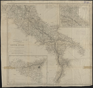
Central and south Italy : to accompany the handbooks for travellers
1642.
Central business district urban renewal area project no. Mass. R-82L site preparation contract T : planting plan and details
1643.
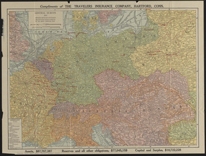
Central Europe, 1914 : showing important fortresses and strategic points affected by the great European war
1644.
Central part of Boston Elevated Railway system showing connections
1645.
Central part of Boston Elevated Railway system showing connections
1646.
Central part of Boston Elevated Railway system showing connections 1903
1647.
Central part of Boston Elevated Railway system showing connections 1904
1648.
Central Virginia showing Lieut. Gen'l. U.S. Grant's Campaign and marches of the armies under his command in 1864-65
1649.
Central-America, southern shore of the Caribbean Sea, harbor of San Juan del Norte or Greytown
1650.
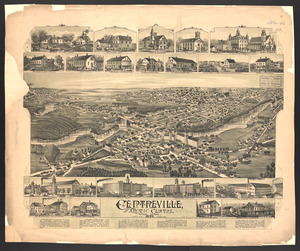
Centreville and Artic Centre, Rhode Island
1651.
Cereal map of Alberta : showing acreage under crop in each township in wheat, oats, barley and flax
1652.
Cestria comitatus Palatinus = the Countye Palatine of Chester
1653.
C.H. Guild & Co.'s newspaper map of New England
1654.
Change in median housing value, 2010 to 2018
1655.
Change in white population (non-Hispanic), 2010 to 2018
1656.
Changes in the bed of Boston Harbor from a comparison of the surveys of 1835-61
1657.
Channel on the north side of Vanua Levu from Aramula Passage to Muthuata Island, Feejee Islands
1658.
Channel on the north side of Vanua Levu from Aramula Passage to Muthuata Island, Feejee Islands
1659.
Chapinville, Mass : 1887
1660.
Chapman's new sectional map of Wisconsin
‹ Prev
Next ›
1
2
…
79
80
81
82
83
84
85
86
87
…
442
443