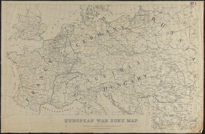
Central Europe, 1914 : showing important fortresses and strategic points affected by the great European war

Item Information
- Title:
- Central Europe, 1914 : showing important fortresses and strategic points affected by the great European war
- Title (alt.):
-
War map of Europe showing the war strength of the powers : also the location of the fortresses and strategic points
- Publisher:
- Rand McNally and Company
- Date:
-
1914
- Format:
-
Maps/Atlases
- Location:
-
Boston Public Library
Norman B. Leventhal Map & Education Center - Collection (local):
-
Norman B. Leventhal Map & Education Center Collection
- Subjects:
-
World War, 1914-1918--Maps
Europe, Central--Maps
- Places:
-
Central Europe (area)
- Extent:
- 1 map : color ; 38 x 52 cm
- Terms of Use:
-
No known copyright restrictions.
No known restrictions on use.
- Publisher:
-
N.Y. :
Rand McNally & Co.
- Scale:
-
Scale approximately 1:3,840,000
- Language:
-
English
- Notes:
-
Relief shown by hachures.
Shows shipping routes.
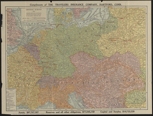
In upper margin: "Compliments of The Travelers Insurance Company, Hartford, Conn."
In lower margin: dollar amounts of assets, reserves and their obligations, capital and surplus.
Along lower left-side of map references Germany's states, grand duchies, duchies, principalities, republics and imperial territory.
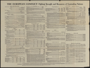
Along top of verso border "The European conflict fighting strength and resources of contending nations."
The war strength of the armies and navies of the nations in conflict, also the area, population, financial resources, public debt, and other pertinent statistics of the powers is listed on the verso.
- Identifier:
-
06_01_014105
06_01_016671
- Call #:
-
G6031.S65 1914 .R36
- Barcode:
-
39999065699348