Toggle navigation
LMEC Home
Exhibitions
Georeferencing
Tools for Teachers
Collections
My Favorites
Sign Up / Log In
Search
Search the map portal
Map Collection
Map Collection
Map Sets
Search
Search
Search for
Search In
All Fields
Creator
Title
Subject
Place
Search All Digital Collections
Advanced Search
8554 Results
My Search
Start Over
More Like
commonwealth:st74cx384
Remove constraint More Like: commonwealth:st74cx384
Filter your Search
Place
North and Central America
5,847
United States
4,770
Massachusetts
2,052
Europe
1,359
Suffolk (county)
1,034
Boston
1,007
Canada
452
Asia
422
more
Place
»
Topic
Boston (Mass.)--Maps
577
United States--Maps
273
Real property--Massachusetts--Boston--Maps
174
Massachusetts--Maps
160
Landowners--Massachusetts--Boston--Maps
132
North America--Maps--Early works to 1800
103
New England--Maps
99
Europe--Maps
78
more
Topic
»
Date
Date range begin
–
Date range end
Current results range from
1482
to
2023
View distribution
Creator
United States. Hydrographic Office
594
O.H. Bailey & Co
148
Des Barres, Joseph F. W. (Joseph Frederick Wallet), 1722-1824
123
United States. Post Office Dept
120
Ptolemy, 2nd cent
100
Walling, Henry Francis, 1825-1888
94
Geological Survey (U.S.)
86
Jefferys, Thomas, -1771
85
more
Creator
»
Format
Maps/Atlases
8,495
Manuscripts
215
Prints
56
Books
36
Objects/Artifacts
10
Drawings/Illustrations
8
Posters
4
Georeferenced
Yes
869
No
7,685
Collection
Norman B. Leventhal Map & Education Center Collection
8,549
Boston and New England Maps
2,204
Urban Maps
1,936
Maritime Charts and Atlases
1,081
American Revolutionary War-Era Maps
621
Boston Redevelopment Authority Collection
87
Richard H. Brown Revolutionary War Map Collection at Mount Vernon
3
Library and Archives Canada Collection
2
Available to use
No known restrictions
8,408
Creative Commons license
49
Search Constraints
Sort by relevance
relevance
title
date (asc)
date (desc)
Number of results to display per page
20 per page
10
per page
20
per page
50
per page
100
per page
View results as:
grid view
map view
Search Results
1.
Chart of the Streights of Belle Isle
2.
Tierra nveva
3.
Canada orientale nell' America Settentrionale
4.
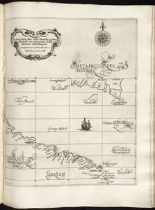
Carta particolare della Meta Incognita Australe con una parte della America Settentrionale
5.
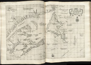
Carta particolare della terra nuoua con la Gran Baia et il Fiume Grande della Canida
6.
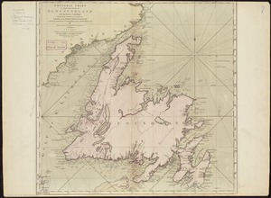
A general chart of the island of Newfoundland with the rocks & soundings
7.
New Found Land, St. Laurence Bay, the fishing banks, Acadia, and part of New Scotland
8.
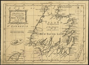
A new map of the only useful and frequented part of New Found Land
9.
Plans des isles, rades, et ports de plusieurs lieux de l'Amérique : tirés de la Carte angloise de Mr. Popple publiée en 1733...
10.
Carte d'une partie de l'Amérique Septentrionale : pour servir à l'intellegence du mémoire sur les prétentions des Anglois...
11.
A map of the inhabited part of Canada from the French surveys : with the frontiers of New York and New England from the large...
12.
A map of the provinces of New-York and New Jersey, with a part of Pennsylvania and the Province of Quebec
13.
A new map of the Province of Quebec, according to the Royal Proclamation, of the 7th of October 1763 : from the French surveys...
14.
A new map of the province of Quebec in North America, drawn from the best authorities
15.
The provinces of New York and New Jersey : with part of Pensilvania, and the Province of Quebec
16.
A chart of the sea-coast of Newfoundland between St. Laurence and Point May survey'd by order of Hugh Palliser esqr. commodore...
17.
A sketch of the River Exploits and the east end of Lieutenants Lake in Newfoundland
18.
Karte von dem Ostlichen-Stucke von Neu Franckreich oder Canada in America : besonders aber Acadia und Neu Schottland
19.
Lauff des flusses St. Laurentzi von Quebec bis an den See Ontario : 2. bladt
20.
A map of the inhabited part of Canada from the French surveys : with the frontiers of New York and New England from the large...
‹ Prev
Next ›
1
2
3
4
5
…
427
428