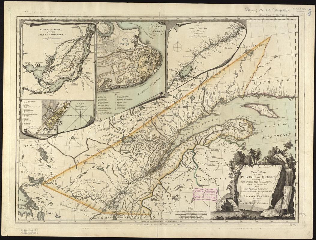
A new map of the Province of Quebec, according to the Royal Proclamation, of the 7th of October 1763 : from the French surveys connected with those made after the war
This map is also available in American Revolutionary Geographies Online (ARGO), a collections portal especially built for material relating to the American Revolutionary War Era. Visit ARGO to learn more about this item and explore the historical geography of North America in the late eighteenth century.
Item Information
- Title:
- A new map of the Province of Quebec, according to the Royal Proclamation, of the 7th of October 1763 : from the French surveys connected with those made after the war
- Creator:
- Carver, Jonathan, 1710-1780
- Name on Item:
-
by Captain Carver, and other officers, in His Majesty's service.
- Date:
-
1776
- Format:
-
Maps/Atlases
- Location:
-
Boston Public Library
Norman B. Leventhal Map & Education Center - Collection (local):
-
Norman B. Leventhal Map & Education Center Collection
- Subjects:
-
Québec (Province)--Maps--Early works to 1800
- Places:
-
CanadaQuebec (province)
- Extent:
- 1 map : col. ; 56 x 74 cm.
- Terms of Use:
-
No known copyright restrictions.
No known restrictions on use.
- Publisher:
-
London :
Printed for Robt. Sayer and John Bennett
- Scale:
-
Scale ca. 1:2,250,000.
- Language:
-
English
- Notes:
-
Relief shown pictorially.
Hand colored.
Insets with indexes: A particular survey of the Isles of Montreal, The city of Quebec, Course of the river St. Laurence, from La Valterie to Quebec and Plan of Montreal, or Víllemarie.
With the conclusion of the French and Indian War, France ceded its Canadian possessions to England. This map delineates the boundaries of the new British province of Quebec as established by royal proclamation in 1763. Despite British administrative control of this area, French culture remained strong, especially with regard to settlement patterns and place names. For example, the map's insets show the two major French trading centers -- Quebec City and Montreal -- as well as the French villages and place names in the vicinity of Montreal and the French land holding system (known as the seigneurial system) along the lower St. Lawrence River. Jonathan Carver, a New Englander who was involved in the British attack on Canada during the French and Indian War, prepared this map. Following the conflict, he undertook explorations of the new British territorial acquisitions in the Great Lakes region. His observations were published in London, as Travels through the Interior Parts of North America in the years 1766,1767, and 1768, a popular travel account but of questionable authenticity.
Featured in the Faces & Places Exhibit, Kravis Center, Palm Beach, FL, since 2005. MB (BRL)
- Identifier:
-
06_01_008023
- Call #:
-
G3450 1763 .C37
- Barcode:
-
39999052509088


