Toggle navigation
LMEC Home
Exhibitions
Georeferencing
Tools for Teachers
Collections
My Favorites
Sign Up / Log In
Search
Search the map portal
Map Collection
Map Collection
Map Sets
Search
Search
Search for
Search In
All Fields
Creator
Title
Subject
Place
Search All Digital Collections
Advanced Search
8743 Results
My Search
Start Over
More Like
commonwealth:q524n409d
Remove constraint More Like: commonwealth:q524n409d
Filter your Search
Place
North and Central America
5,966
United States
4,888
Massachusetts
2,079
Europe
1,396
Suffolk (county)
1,046
Boston
1,019
Canada
463
Asia
438
more
Place
»
Topic
Boston (Mass.)--Maps
586
United States--Maps
330
Real property--Massachusetts--Boston--Maps
175
Massachusetts--Maps
162
Landowners--Massachusetts--Boston--Maps
133
North America--Maps--Early works to 1800
103
New England--Maps
102
Europe--Maps
79
more
Topic
»
Date
Date range begin
–
Date range end
Current results range from
1482
to
2023
View distribution
Creator
United States. Hydrographic Office
595
O.H. Bailey & Co
148
Des Barres, Joseph F. W. (Joseph Frederick Wallet), 1722-1824
123
United States. Post Office Dept
120
Ptolemy, 2nd cent
100
Walling, Henry Francis, 1825-1888
94
Geological Survey (U.S.)
87
Jefferys, Thomas, -1771
85
more
Creator
»
Format
Maps/Atlases
8,684
Manuscripts
215
Prints
56
Books
36
Objects/Artifacts
10
Drawings/Illustrations
8
Posters
4
Georeferenced
Yes
871
No
7,872
Collection
Norman B. Leventhal Map & Education Center Collection
8,700
Boston and New England Maps
2,233
Urban Maps
2,023
Maritime Charts and Atlases
1,083
American Revolutionary War-Era Maps
657
Boston Redevelopment Authority Collection
87
American Antiquarian Society Collection
20
William L. Clements Library Collection
13
more
Collection
»
Available to use
No known restrictions
8,556
Creative Commons license
50
Search Constraints
Sort by relevance
relevance
title
date (asc)
date (desc)
Number of results to display per page
20 per page
10
per page
20
per page
50
per page
100
per page
View results as:
grid view
map view
Search Results
3901.
Map of Massachusetts, Connecticut and Rhode Island constructed from the latest authorities
3902.
Map of Massachusetts, Connecticut and Rhode Island constructed from the latest authorities
3903.
Map of Massachusetts, Connecticut and Rhode Island constructed from the latest authorities
3904.
A map of Massachusetts, Connecticut and Rhodeisland
3905.
A map of Massachusetts, exhibiting the boundary lines of each town and county : compiled from the latest authorities, embracing...
3906.
Map of Massachusetts proper
3907.
Map of Massachusetts, Rhode-Island & Connecticut : compiled from the latest authorities
3908.
Map of Massachusetts, Rhode-Island & Connecticut : compiled from the latest authorities
3909.
Map of Massachusetts showing population according to census of 1910
3910.
Map of Massachusetts showing population according to United States Census of 1900 and congressional districts
3911.
Map of Massachusetts showing state highways laid out & petitioned for
3912.
Map of Massachusetts showing state highways laid out & petitioned for
3913.
Map of Massachusetts showing state highways laid out and petitioned for
3914.
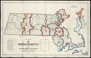
A map of Massachusetts, showing the congressional districts, as proposed by the Senate of 1852
3915.
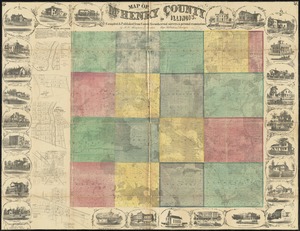
Map of McHenry County, Illinois
3916.
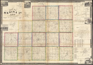
Map of Medina Co., Ohio
3917.
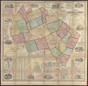
Map of Merrimack County, New Hampshire
3918.
A Map of Methuen, Mass
3919.
Map of Mexico, constructed from all available materials and corrected to 1862 = H. Kiepert's karte von Mexico, überdruck aus...
3920.
Map of Middlesex County, Mass : copied from a map belonging to the state, with various additions and alterations, by order of...
‹ Prev
Next ›
1
2
…
192
193
194
195
196
197
198
199
200
…
437
438