Toggle navigation
LMEC Home
Exhibitions
Georeferencing
Tools for Teachers
Collections
My Favorites
Sign Up / Log In
Search
Search the map portal
Map Collection
Map Collection
Map Sets
Search
Search
Search for
Search In
All Fields
Creator
Title
Subject
Place
Search All Digital Collections
Advanced Search
8595 Results
My Search
Start Over
More Like
commonwealth:q524n199z
Remove constraint More Like: commonwealth:q524n199z
Filter your Search
Place
North and Central America
5,881
United States
4,810
Massachusetts
2,052
Europe
1,359
Suffolk (county)
1,034
Boston
1,007
Canada
462
Asia
422
more
Place
»
Topic
Boston (Mass.)--Maps
577
United States--Maps
314
Real property--Massachusetts--Boston--Maps
174
Massachusetts--Maps
160
Landowners--Massachusetts--Boston--Maps
132
North America--Maps--Early works to 1800
103
New England--Maps
99
Europe--Maps
78
more
Topic
»
Date
Date range begin
–
Date range end
Current results range from
1482
to
2023
View distribution
Creator
United States. Hydrographic Office
594
O.H. Bailey & Co
148
Des Barres, Joseph F. W. (Joseph Frederick Wallet), 1722-1824
123
United States. Post Office Dept
120
Ptolemy, 2nd cent
100
Walling, Henry Francis, 1825-1888
94
Geological Survey (U.S.)
87
Jefferys, Thomas, -1771
85
more
Creator
»
Format
Maps/Atlases
8,536
Manuscripts
215
Prints
56
Books
36
Objects/Artifacts
10
Drawings/Illustrations
8
Posters
4
Georeferenced
Yes
871
No
7,724
Collection
Norman B. Leventhal Map & Education Center Collection
8,554
Boston and New England Maps
2,204
Urban Maps
1,936
Maritime Charts and Atlases
1,081
American Revolutionary War-Era Maps
655
Boston Redevelopment Authority Collection
87
American Antiquarian Society Collection
20
William L. Clements Library Collection
17
more
Collection
»
Available to use
No known restrictions
8,412
Creative Commons license
49
Search Constraints
Sort by relevance
relevance
title
date (asc)
date (desc)
Number of results to display per page
20 per page
10
per page
20
per page
50
per page
100
per page
View results as:
grid view
map view
Search Results
1.
Bancroft's map of the Rocky Mountain states, and the Pacific coast
2.
Carta geografica general de la republica Mexicana
3.
The Chevron trail through the scenic west
4.
Great Northern Railway and proprietary lines
5.
Louisiana
6.
Map of a tour from Independence to Santa Fé, Chihuahua, Monterey and Matamoros
7.
Map of Oregon and upper California, from the surveys of John Charles Frémont and other authorities
8.
Map of routes for a Pacific railroad
9.
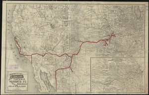
Map of the Atchison Topeka and Santa Fe Railroad and its leased lines
10.
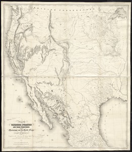
Map of the United States and their territories between the Mississippi and the Pacific Ocean; and part of Mexico
11.
Map seventh division railway mail service
12.
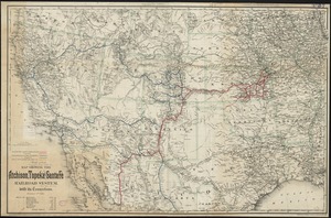
Map showing the Atchison, Topeka and Santa Fe railroad system : with its connections
13.
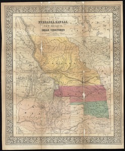
A new map of Nebraska, Kansas, New Mexico, and Indian Territories
14.
19th annual convention of the National Association of Real Estate Boards : at Tulsa, June 7 to June 11 in 1926
15.
2005 significant U.S. hurricane strikes
16.
The 2100 project : an atlas for the Green New Deal
17.
38,000,000 escaped -- 10,000,000 died
18.
Abolition of Slavery, 1863
19.
Aboriginal map of North America, denoting the boundaries and the locations of various Indian tribes
20.
The adventures of Mark Twain
‹ Prev
Next ›
1
2
3
4
5
…
429
430