Toggle navigation
LMEC Home
Exhibitions
Georeferencing
Tools for Teachers
Collections
My Favorites
Sign Up / Log In
Search
Search the map portal
Map Collection
Map Collection
Map Sets
Search
Search
Search for
Search In
All Fields
Creator
Title
Subject
Place
Search All Digital Collections
Advanced Search
370 Results
My Search
Start Over
More Like
commonwealth:q524mv470
Remove constraint More Like: commonwealth:q524mv470
Filter your Search
Place
North and Central America
303
United States
232
Pennsylvania
40
New York
37
Virginia
37
Canada
31
North America
31
Suffolk (county)
31
more
Place
»
Topic
Virginia--Maps--Early works to 1800
38
Pennsylvania--Maps--Early works to 1800
37
North America--Maps--Early works to 1800
23
Maryland--Maps--Early works to 1800
22
United States--History--French and Indian War, 1754-1763--Maps--Early works to 1800
17
Boston (Mass.)--History--Revolution, 1775-1783--Maps--Early works to 1800
16
New Jersey--Maps--Early works to 1800
12
Middle Atlantic States--Maps--Early works to 1800
10
more
Topic
»
Date
Date range begin
–
Date range end
Current results range from
1590
to
1799
View distribution
Creator
Jefferys, Thomas, -1771
37
Faden, William, 1749-1836
34
Sayer, Robert, 1725-1794
24
Le Rouge, Georges-Louis
23
Des Barres, Joseph F. W. (Joseph Frederick Wallet), 1722-1824
22
Korn, Christoph Heinrich, 1726-1783
11
Raspe, Gabriel Nicolaus, 1712-1785
11
Robert Sayer and John Bennett (Firm)
10
more
Creator
»
Format
Maps/Atlases
327
Prints
32
Manuscripts
25
Drawings/Illustrations
9
Books
2
Georeferenced
Yes
16
No
354
Collection
American Revolutionary War-Era Maps
352
Richard H. Brown Revolutionary War Map Collection at Mount Vernon
293
Norman B. Leventhal Map & Education Center Collection
42
MacLean Collection Map Library
18
New York Public Library Collection
8
Maritime Charts and Atlases
5
Boston and New England Maps
4
British Library Collection
3
more
Collection
»
Available to use
Creative Commons license
306
No known restrictions
44
Search Constraints
Sort by relevance
relevance
title
date (asc)
date (desc)
Number of results to display per page
20 per page
10
per page
20
per page
50
per page
100
per page
View results as:
grid view
map view
Search Results
21.
Virginia and Maryland
22.
Virginia Marylandia et Carolina in America septentrionali Brittannorum industria excultæ
23.
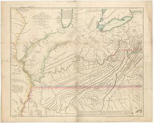
A new map of the western parts of Virginia, Pennsylvania, Maryland and North Carolina : comprehending the river Ohio, and all...
24.
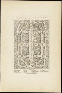
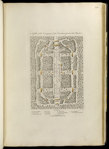
A plan of the encampment of the detachment from the little Meadows
25.
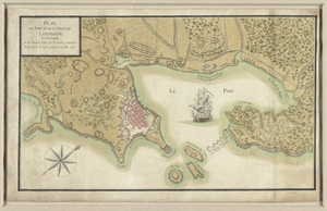
Carte topographique du port et de la ville de Louisbourg, assiegé par les Anglais pendant les mois de Juin, Juillet 1758
26.
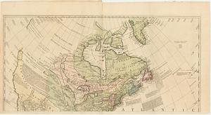
A general map of North America : in which is express'd the several new roads, forts, engagements, &c, taken from actual surveys...
27.
A new and accurate map of the English empire in North America : representing their rightful claim as confirmed by charters, and...
28.
Plan de la ville de Louisbourg avec les ouvrages d'attaque des Anglais pour sa reddition, ainsi que ceux des assiegés pr. la...
29.
Plan du fort et ville de Louisbourg dans l'Isle Roale
30.
Plan du port et de la ville de Louisbourg en l'Isle Royale, et des attaques faites par les Anglois pendant le siége dépuis le...
31.
Theodolite's pattern, shewing the provinces in North America which were in the respective possessions of England, France &...
32.
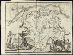
A topographical plan of that part of the Indian-country through which Colonel Bouquet marched in the year, 1764
33.
Map of the western parts of the colony of Virginia, as far as the Mississipi
34.
A plan of the encampment of the detachment from the little Meadows
35.
An accurate map of His Majesty's province of New Hampshire in New England, taken from actual surveys of all the inhabited part,...
36.
A correct plan of the environs of Quebec, and of the battle fought on the 13th September, 1759 : together with a particular...
37.
A general map of North America : in which is express'd the several new roads, forts, engagements, &c, taken from actual surveys...
38.
A general map of North America; in which is express'd the several new roads, forts, engagements, &c. taken from actual surveys...
39.
A map of the several dispositions of the English Fleet & Army on the River St. Laurence to the taking of Quebec
40.
A new and accurate map of the English empire in North America : representing their rightful claim as confirm'd by charters, and...
‹ Prev
Next ›
1
2
3
4
5
6
…
18
19