Toggle navigation
LMEC Home
Exhibitions
Georeferencing
Tools for Teachers
Collections
My Favorites
Sign Up / Log In
Search
Search the map portal
Map Collection
Map Collection
Map Sets
Search
Search
Search for
Search In
All Fields
Creator
Title
Subject
Place
Search All Digital Collections
Advanced Search
29 Results
My Search
Start Over
More Like
commonwealth:p8418t59t
Remove constraint More Like: commonwealth:p8418t59t
Filter your Search
Place
United States
27
North and Central America
26
New York
8
Freehold
5
Monmouth (county)
5
Middletown
4
New Jersey
4
Westchester (county)
4
more
Place
»
Topic
United States--History--Revolution, 1775-1783--Maps
7
Landforms--New York (State)--Maps
6
Rivers--New York (State)--Maps
6
Roads--New York (State)--Maps
6
Buildings--New York (State)--Maps
5
Monmouth, Battle of, Freehold, N.J., 1778--Maps
5
Buildings--New York (State)--New York--Maps
4
Landowners--New York (State)--Maps
4
more
Topic
»
Date
Date range begin
–
Date range end
Current results range from
1755
to
1826
View distribution
Creator
Clinton, Henry, Sir, 1738?-1795
3
Erskine, Robert, 1735-1780
3
Faden, William, 1749-1836
3
De Witt, Simeon, 1756-1834
2
Kitchin, Thomas, 1719-1784
2
Robert Sayer and John Bennett (Firm)
2
Barber, J.
1
Bauman, Sebastian
1
more
Creator
»
Format
Maps/Atlases
29
Manuscripts
9
Georeferenced
No
29
Collection
American Revolutionary War-Era Maps
29
New-York Historical Society Collection
24
William L. Clements Library Collection
4
Richard H. Brown Revolutionary War Map Collection at Mount Vernon
1
Available to use
No known restrictions
24
Creative Commons license
1
Search Constraints
Sort by relevance
relevance
title
date (asc)
date (desc)
Number of results to display per page
20 per page
10
per page
20
per page
50
per page
100
per page
View results as:
grid view
map view
Search Results
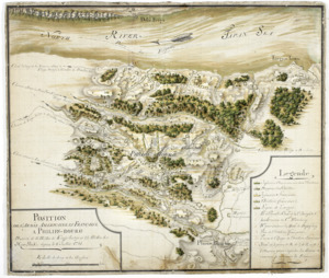
21.
Position de 'larmee Américane et Française a Philips-bourg : distante de 12 milles de Kings-bridge et 25 milles de New-York,...
22.
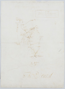
Road from the White Plains to Bloomer's Mill at Rye Neck, and Cross Roads : no 20
23.
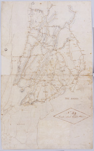
Roads about White Plains : no 59
24.
The seat of war, in New England, by an American volunteer : with the marches of the several corps sent by the colonies, towards...
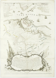
25.
This plan of the City of New York (within the palisades which were erected in the year 1743) was made for the purpose of...
26.
To His Excellency Genl. Washington, Commander in Chief of the armies of the United States of America : this plan of the...
27.
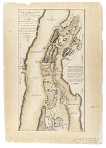
A Topographical map of the northn. part of New York Island, exhibitg. the plan of Fort Washington now Fort Knyphausen, with the...
28.
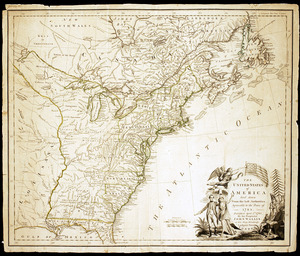
The United States of America laid down from the best authorities, agreeable to the Peace of 1783
29.
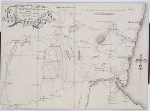
The Winter-Cantonment of the American Army and it's Vicinity for 1783
‹ Prev
Next ›
1
2