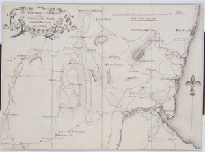
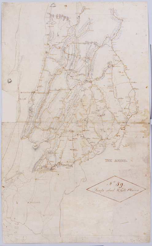
Roads about White Plains : no 59
This map is also available in American Revolutionary Geographies Online (ARGO), a collections portal especially built for material relating to the American Revolutionary War Era. Visit ARGO to learn more about this item and explore the historical geography of North America in the late eighteenth century.
Item Information
- Title:
- Roads about White Plains : no 59
- Title (alt.):
-
Do. About White Plains
Ditto About White Plains
Contraction About White Plains
Near the White Plains across from Sawmill River toward the Brunks to near Thos. Thompsons
- Cartographer:
- Erskine, Robert, 1735-1780
- Name on Item:
-
by Robert Erskine F.R.S. Geogr. A. U.S. and Assistants
- Date:
-
1779
- Format:
-
Maps/Atlases
Manuscripts
- Location:
- New-York Historical Society
- Collection (local):
-
New-York Historical Society Collection
- Subjects:
-
Hudson River Valley (N.Y. and N.J.)--History--18th century--Campaigns--Maps
Westchester County (N.Y.)--History--18th century--Campaigns--Maps
Fairfield County (Conn.)--History--Revolution, 1775-1783--Campaigns--Maps
New York (N.Y.)--History--Revolution, 1775-1783--Campaigns--Maps
Buildings--New York (State)--Maps
Landforms--New York (State)--Maps
Landowners--New York (State)--Maps
Roads--New York (State)--Maps
Rivers--New York (State)--Maps
Buildings--Connecticut--Maps
Landowners--Connecticut--Maps
Landforms--Connecticut--Maps
Roads--Connecticut--Maps
Rivers--Connecticut--Maps
- Places:
-
Fairfield (county)
New York
- Extent:
- 1 map : ms. ; 66 x 41 cm.
- Terms of Use:
-
No known copyright restrictions.
No known restrictions on use.
- Scale:
-
Scale [ca. 1:63,000]
- Language:
-
English
- Catalog Record:
-
https://library.nyu.edu/persistent/lcn/nyu_aleph001665155?institution=NYU&persistent
- Notes:
-
Military topographic map. Covers most of Westchester County, New York and western Fairfield County, Connecticut; also covers northern New York City. Shows roads, buildings and owners' names, also landforms and streams.
Shows relief by hachures.
Title proper from recto is the work of a later editor--Simeon DeWitt or his assign--subsequent to 1820. Index title, statement of responsibility, date, series title and series numbering by Erskine, but on separate index sheet filed at head of series.
A variant of the title given by Guthorn appears on map No. 120 of the series which, as soiling shows, was once pasted above the lower margin of this map, no. 59.
Pen-and-ink, pencil on laid paper.
Watermark: "J WHATMAN."
In ink on verso: "No. 59 Joined to No. 25. 32 & 60." There is no evidence that these sheets were ever physically joined, although nos. 25 and 32 do cover adjacent areas. (Map no. 25 is missing.) No. 60 is a copy of this map, no. 59.
- Notes (citation):
-
Guthorn, Peter J. American Maps and Map Makers of the Revolution, p. 17-22
- Identifier:
-
M30_No59