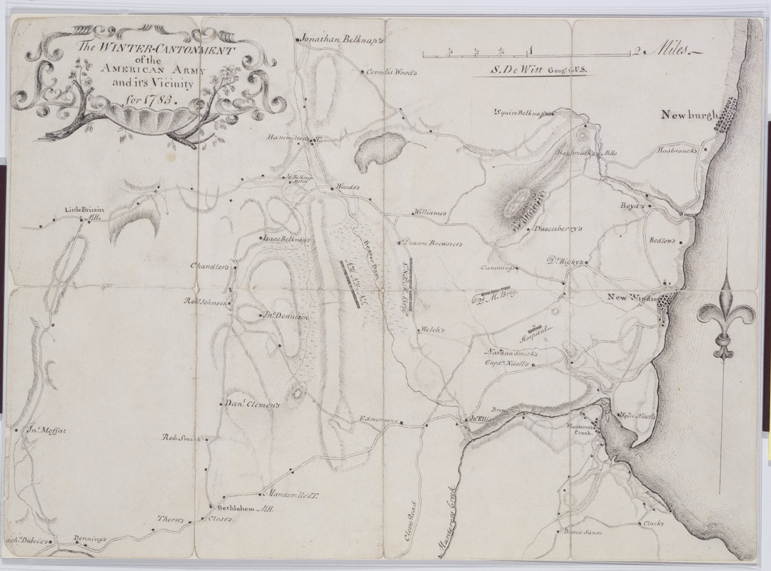
The Winter-Cantonment of the American Army and it's Vicinity for 1783
This map is also available in American Revolutionary Geographies Online (ARGO), a collections portal especially built for material relating to the American Revolutionary War Era. Visit ARGO to learn more about this item and explore the historical geography of North America in the late eighteenth century.
Item Information
- Title:
- The Winter-Cantonment of the American Army and it's Vicinity for 1783
- Title (alt.):
-
Encampment American Army 1783 near New Windsor
- Cartographer:
- De Witt, Simeon, 1756-1834
- Name on Item:
-
S. De Witt Geogr. to U.S.
- Date:
-
1783
- Format:
-
Maps/Atlases
Manuscripts
- Location:
- New-York Historical Society
- Collection (local):
-
New-York Historical Society Collection
- Subjects:
-
Hudson River Valley (N.Y. and N.J.)--History--18th century--Campaigns--Maps
Orange County (N.Y.)--History--18th century--Campaigns--Maps
Buildings--New York (State)--Maps
Landforms--New York (State)--Maps
Landowners--New York (State)--Maps
Roads--New York (State)--Maps
Rivers--New York (State)--Maps
- Places:
-
Orange (county)
- Extent:
- 1 map : ms. ; 28 x 38 cm.
- Terms of Use:
-
No known copyright restrictions.
No known restrictions on use.
- Scale:
-
Scale [ca. 1:31,000]
- Language:
-
English
- Catalog Record:
-
https://library.nyu.edu/persistent/lcn/nyu_aleph001700137?institution=NYU&persistent
- Notes:
-
Military topographic map. Covers the townships of Newburg, New Windsor, Cornwall and Blooming Grove in Orange County, New York. Shows roads, streams, landforms, buildings and owners' names.
Shows relief by hachures.
Title proper from recto is original. Title from verso may have been added in the 19th century.
Pen-and-ink on laid paper.
Watermark: partial crest (from Whatman paper).
- Notes (citation):
-
Guthorn, Peter J. American maps and map makers of the revolution, p. 16
- Identifier:
-
M30_1_3