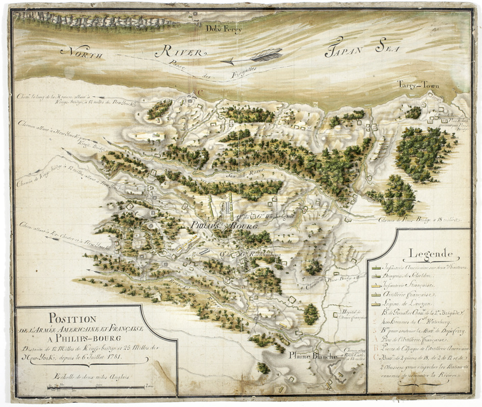
Position de 'larmee Américane et Française a Philips-bourg : distante de 12 milles de Kings-bridge et 25 milles de New-York, depuis le 6 Juillet 1781
This map is also available in American Revolutionary Geographies Online (ARGO), a collections portal especially built for material relating to the American Revolutionary War Era. Visit ARGO to learn more about this item and explore the historical geography of North America in the late eighteenth century.
Item Information
- Title:
- Position de 'larmee Américane et Française a Philips-bourg : distante de 12 milles de Kings-bridge et 25 milles de New-York, depuis le 6 Juillet 1781
- Description:
-
Military battlefield map. Covers the town of Greenburgh in Westchester County, New York: Shows disposition of troops, cavalry and artillery. Also shows roads running through Tarrytown, Dobbs Ferry and White Plains. Also shows buildings, landforms, streams and vegetative cover.||Shows relief by shading.||Pen-and-ink, watercolor on laid paper.||Includes key.||On verso: "[?]aris Dessins topographiques"
- Date:
-
[1781?]
- Format:
-
Maps/Atlases
Manuscripts
- Location:
- New-York Historical Society
- Collection (local):
-
New-York Historical Society Collection
- Subjects:
-
Westchester County (N.Y.)--History--18th century--Maps
Battlefields--New York (State)--Maps
Buildings--New York (State)--Maps
Landforms--New York (State)--Maps
Roads--New York (State)--Maps
Rivers--New York (State)--Maps
- Places:
-
Westchester (county)
- Extent:
- 1 map : ms. ; 35 x 41 cm.
- Terms of Use:
-
No known copyright restrictions.
No known restrictions on use.
- Scale:
-
Scale [ca. 1:39,000]
- Language:
-
French
- Catalog Record:
-
https://library.nyu.edu/persistent/lcn/nyu_aleph001713493?institution=NYU&persistent
- Identifier:
-
84632d_PositionDeLArmeeAmericaineEtFrancaisePhilipsbourg