Toggle navigation
LMEC Home
Exhibitions
Georeferencing
Tools for Teachers
Collections
My Favorites
Sign Up / Log In
Search
Search the map portal
Map Collection
Map Collection
Map Sets
Search
Search
Search for
Search In
All Fields
Creator
Title
Subject
Place
Search All Digital Collections
Advanced Search
82 Results
My Search
Start Over
More Like
commonwealth:p8418t43x
Remove constraint More Like: commonwealth:p8418t43x
Filter your Search
Place
United States
70
North and Central America
69
New York
22
North America
11
Canada
10
New Jersey
10
Westchester (county)
9
Boston
4
more
Place
»
Topic
United States--History--Revolution, 1775-1783--Maps--Early works to 1800
38
New Jersey--History--Revolution, 1775-1783--Maps--Early works to 1800
14
New York (State)--History--Revolution, 1775-1783--Maps--Early works to 1800
14
United States--Maps--Early works to 1800
8
White Plains, Battle of, White Plains, N.Y., 1776--Maps--Early works to 1800
7
Landforms--New York (State)--Maps
6
North America--History--Revolution, 1775-1783--Maps--Early works to 1800
6
North America--Maps--Early works to 1800
6
more
Topic
»
Date
Date range begin
–
Date range end
Current results range from
1755
to
1826
View distribution
Creator
Faden, William, 1749-1836
11
Bonne, Rigobert, 1727-1794
4
Brion de la Tour, Louis
3
Erskine, Robert, 1735-1780
3
Kitchin, Thomas, 1719-1784
3
Korn, Christoph Heinrich, 1726-1783
3
Lattré, Jean
3
Lodge, John, -1796
3
more
Creator
»
Format
Maps/Atlases
82
Manuscripts
14
Georeferenced
Yes
1
No
81
Collection
American Revolutionary War-Era Maps
82
Norman B. Leventhal Map & Education Center Collection
26
New-York Historical Society Collection
24
Richard H. Brown Revolutionary War Map Collection at Mount Vernon
14
Boston and New England Maps
5
Harvard Map Collection
5
New York Public Library Collection
4
Boston Athenaeum, Cartographic Collection
2
more
Collection
»
Available to use
No known restrictions
50
Creative Commons license
27
Search Constraints
Sort by relevance
relevance
title
date (asc)
date (desc)
Number of results to display per page
20 per page
10
per page
20
per page
50
per page
100
per page
View results as:
grid view
map view
Search Results
21.
Chart and plan of the harbour of New York & the couny. adjacent, from Sandy Hook to Kingsbridge, comprehending the whole of New...
22.
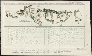
Plan de la bataille de Montmouth où le Gl. Washington commandait l'Armée Américaine et le Gl. Clinton l'Armée Anglaise, le...
23.
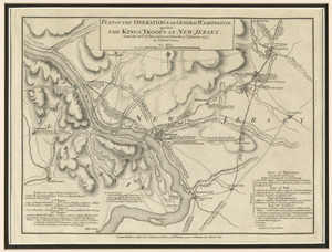
Plan of the operations of General Washington, against the Kings troops in New Jersey : from the 26th. of December 1776, to the...
24.
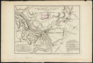
Plan of the operations of General Washington, against the Kings troops in New Jersey : from the 26th. of December 1776, to the...
25.
Plan of the situation of the American & British armies, June 15st 1777
26.
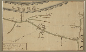
Boston, its environs and harbour, with the rebel works raised against that town in 1775 : from the observations of Lieut. Page...
27.
Boston with its environs
28.
Bowles's map of the seat of war in New England, comprehending the provinces of Massachusets Bay, and New Hampshire : with the...
29.
Carte de l'Amérique Septle. pour servir à l'intelligence de la guerre entre les Anglois et les insurgents
30.
Carte de l'Amerique Sept.le pour servir à l'intelligence de la guerre entre les anglois et les insurgents : dédiée à M.gr de...
31.
Carte des Etats-Unis d'Amérique, et du cours du Mississippi : rédigée d'après différentes cartes et relations Anglaises et...
32.
Carte des Etats-Unis de l'Amerique suivant le Traité de Paix de 1783
33.
Carte des Etats-Unis de l'Amerique suivant le Traité de Paix de 1783
34.
Carte des Etats-Unis de l'Amerique suivant le traité de paix de 1783 : dédiée et présentée a s. excellence M.r Benjamin...
35.
Carte du théatre de la guerre entre les Anglais et les Américains
36.
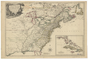
Carte générale des colonies Angloises : dans l'Amérique Septentrionale
37.
Carte generale des colonies angloises dans l'Amerique Septentrionale pour l'intelligence de la guerre presente : d'apres des...
38.
Carte generale des colonies angloises dans l'Amerique Septentrionale pour l'intelligence de la guerre presente : d'apres des...
39.
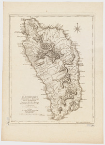
La Dominique située entre La Martinique et La Guadeloupe : conquise par M. le Mis. de Bouillé Marechal des camps et armées du...
40.
A general map of the southern British colonies in America comprehending North and South Carolina, Georgia, East and West...
‹ Prev
Next ›
1
2
3
4
5