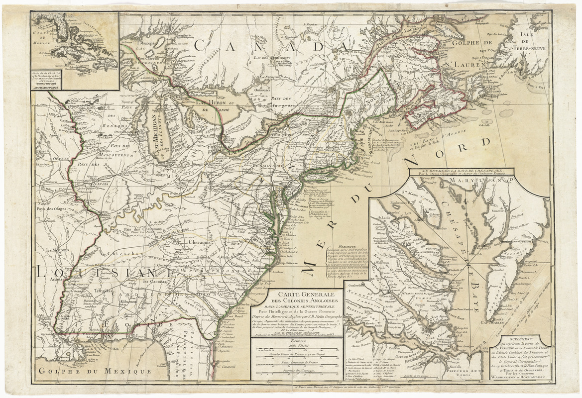
Carte generale des colonies angloises dans l'Amerique Septentrionale pour l'intelligence de la guerre presente : d'apres des manuscrit anglais par J.B. Nolin geographe : corrigé, augmenté des indications des principaux évenemens de la guerre avec le tracee des limites pour constituer le traité de paix proposé entre la Couronne de la Grande Bretagne et les Etats Unis
This map is also available in American Revolutionary Geographies Online (ARGO), a collections portal especially built for material relating to the American Revolutionary War Era. Visit ARGO to learn more about this item and explore the historical geography of North America in the late eighteenth century.
Item Information
- Title:
- Carte generale des colonies angloises dans l'Amerique Septentrionale pour l'intelligence de la guerre presente : d'apres des manuscrit anglais par J.B. Nolin geographe : corrigé, augmenté des indications des principaux évenemens de la guerre avec le tracee des limites pour constituer le traité de paix proposé entre la Couronne de la Grande Bretagne et les Etats Unis
- Description:
-
Shows the boundaries established by the preliminary Treaty of Peace, signed 30 November 1782, and published prior to the signing of the formal Treaty on 3 September 1783. Includes a detailed plan of the Siege of Yorktown.
- Creator:
- Phelipeau, René, active 1748-1784
- Publisher:
- Denis, Louis, 1725-1794
- Publisher:
- Nolin, Jean Baptiste, 1686-1762
- Publisher:
- Basset (Firm)
- Name on Item:
-
par R. Phelipeau, géographe.
- Date:
-
1783
- Format:
-
Maps/Atlases
- Location:
- George Washington's Mount Vernon
- Collection (local):
-
Richard H. Brown Revolutionary War Map Collection at Mount Vernon
- Subjects:
-
Indians of North America--Maps--Early works to 1800
United States--History--Revolution, 1775-1783--Maps--Early works to 1800
Yorktown (Va.)--History--Siege, 1781--Maps--Early works to 1800
- Places:
-
York (county)Yorktown
- Extent:
- 1 map : hand colored ; 50 x 70 cm
- Terms of Use:
-
No known copyright restrictions.
This work is licensed for use under a Creative Commons Attribution Non-Commercial Share Alike License (CC BY-NC-SA).

- Publisher:
-
Paris :
Chez Basset
- Scale:
-
Scale approximately 1:5,000,000
- Language:
-
French
- Catalog Record:
-
MVLA record
- Notes:
-
Relief shown pictorially.
Prime meridian: [Ferro].
Insets: Suite de la Floride et la position des isles Lucayes et des Grandes Antilles -- Suplément qui représente la partie de la Virginie, ou se trouvent le theatre ou l'armé combinée des Francois et des Etats Unis a fait prisonnier le General Cornowalis le 19 Octobre 1781, et le plan d'attaque d'Yorck et de Glocester, par les Generaux Washincton et Rochambeau [title at top of inset: Le detail de la baye de Chesapeake / par L. Denis geographe et auteur du conducteur francois].
Includes historical notes.
- Identifier:
-
06_01_014554


