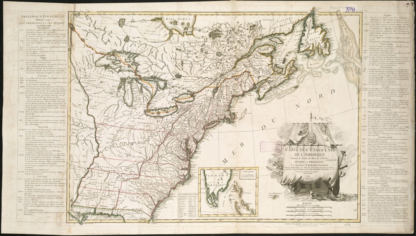
Carte des Etats-Unis de l'Amerique suivant le Traité de Paix de 1783
This map is also available in American Revolutionary Geographies Online (ARGO), a collections portal especially built for material relating to the American Revolutionary War Era. Visit ARGO to learn more about this item and explore the historical geography of North America in the late eighteenth century.
Item Information
- Title:
- Carte des Etats-Unis de l'Amerique suivant le Traité de Paix de 1783
- Description:
-
America Votes exhibition: This is the first map of the new United States issued after the ratification of the Treaty of Paris, formally ending the war with England in 1783. The ship depicted in the cartouche symbolizes the course set by this new independent nation. The distinct delineation of individual state boundaries, however, was an important reminder that the union was composed of individual states, then operating under the Articles of Confederation, and unwilling to cede power to a strong central authority. The map was published in France, America’s primary ally during the Revolution. We Are One exhibition: This 1784 map was the first issued after the ratification of the 1783 Treaty of Paris. Jean Lattré based it on John Mitchell’s 1755 map of North America. He dedicated it to Benjamin Franklin, head of the American delegation to the treaty negotiations. The map lists the major military events of the war and emphasizes state borders, a reminder that the Articles of Confederation only loosely united the states. Published in France, America’s wartime ally, the map commemorates the bond between the two countries. The ship in the cartouche symbolizes French naval assistance and the independent course set by the new United States.
- Creator:
- Lattré, Jean.
- Name on Item:
-
par son trés humble et trés obeissant serviteur Lattrè.
- Date:
-
1784
- Format:
-
Maps/Atlases
- Location:
-
Boston Public Library
Norman B. Leventhal Map & Education Center - Collection (local):
-
Norman B. Leventhal Map & Education Center Collection
- Subjects:
-
United States--History--Revolution, 1775-1783--Maps--Early works to 1800
- Places:
-
United States
- Extent:
- 1 map : hand col. ; 56 x 76 cm.
- Terms of Use:
-
No known copyright restrictions.
No known restrictions on use.
- Publisher:
-
A Paris :
Chez Lattrè
- Scale:
-
Scale [ca. 1:4,800,000]
- Language:
-
French
- Notes:
-
Relief shown pictorially.
Prime meridian: Ferro.
Inset: Suplément a la Floride.
Includes text in margin "Principaux evenemens militaires entre les Americans et les Anglois."
Includes table of the states and capitals.
Decorative title cartouche depicting a ship.
"Dediée et présentée a S. Excellence Mr. Benjamin Franklin."
This map can be viewed as a georeferenced overlay in an interactive application made especially for We Are One: Mapping America's Road from Revolution to Independence http://d2o8owo4k087al.cloudfront.net/index.html?mapId=97.
Cataloging, conservation, and digitization made possible in part by The National Endowment for the Humanities: Exploring the human endeavor.
- Notes (exhibitions):
-
Exhibited: "America Votes: Mapping the Political Landscape" organized by the Norman B. Leventhal Map Center at the Boston Public Library, 2012.
Exhibited: "We Are One: Mapping America's Road from Revolution to Independence" organized by the Norman B. Leventhal Map Center at the Boston Public Library, 2015.
- Identifier:
-
06_01_006162
- Call #:
-
G3700 1783 .L38
- Barcode:
-
39999059020865


