Toggle navigation
LMEC Home
Exhibitions
Georeferencing
Tools for Teachers
Collections
My Favorites
Sign Up / Log In
Search
Search the map portal
Map Collection
Map Collection
Map Sets
Search
Search
Search for
Search In
All Fields
Creator
Title
Subject
Place
Search All Digital Collections
Advanced Search
8703 Results
My Search
Start Over
More Like
commonwealth:kk91fq90k
Remove constraint More Like: commonwealth:kk91fq90k
Filter your Search
Place
North and Central America
5,932
United States
4,849
Massachusetts
2,078
Europe
1,396
Suffolk (county)
1,045
Boston
1,018
Canada
455
Asia
438
more
Place
»
Topic
Boston (Mass.)--Maps
586
United States--Maps
282
Real property--Massachusetts--Boston--Maps
175
Massachusetts--Maps
162
Landowners--Massachusetts--Boston--Maps
133
North America--Maps--Early works to 1800
103
New England--Maps
102
Europe--Maps
79
more
Topic
»
Date
Date range begin
–
Date range end
Current results range from
1482
to
2023
View distribution
Creator
United States. Hydrographic Office
595
O.H. Bailey & Co
148
Des Barres, Joseph F. W. (Joseph Frederick Wallet), 1722-1824
123
United States. Post Office Dept
120
Ptolemy, 2nd cent
100
Walling, Henry Francis, 1825-1888
94
Jefferys, Thomas, -1771
89
Geological Survey (U.S.)
86
more
Creator
»
Format
Maps/Atlases
8,643
Manuscripts
215
Prints
56
Books
36
Objects/Artifacts
10
Drawings/Illustrations
8
Posters
5
Georeferenced
Yes
869
No
7,834
Collection
Norman B. Leventhal Map & Education Center Collection
8,696
Boston and New England Maps
2,232
Urban Maps
2,023
Maritime Charts and Atlases
1,085
American Revolutionary War-Era Maps
622
Boston Redevelopment Authority Collection
87
Mapping Boston Collection
3
Richard H. Brown Revolutionary War Map Collection at Mount Vernon
3
more
Collection
»
Available to use
No known restrictions
8,551
Creative Commons license
54
Search Constraints
Sort by relevance
relevance
title
date (asc)
date (desc)
Number of results to display per page
20 per page
10
per page
20
per page
50
per page
100
per page
View results as:
grid view
map view
Search Results
1.
De Noordelyckste Zee Kusten van America van Groenland door de Straet Davis ende Straet Hudson tot Terra Neuf =...
2.
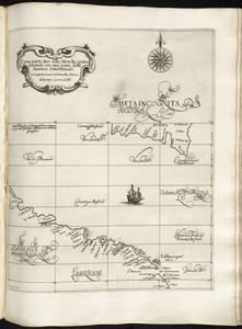
Carta particolare della Meta Incognita Australe con una parte della America Settentrionale
3.
An actual survey of the sea coast from New York to the I. Cape Briton : with tables of the direct and thwart courses &...
4.
The coast of Nova Scotia, New England, New-York, Jersey, the Gulph and River of St. Lawrence : the islands of Newfoundland,...
5.
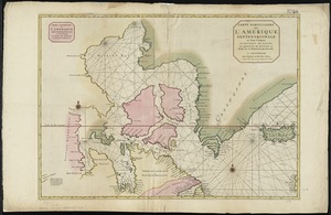
Carte particuliere de l'Amerique septentrionale ou sont compris le Destroit de Davids, le Destroit de Hudson, &c
6.
Chart comprizing Greenland with the countries and islands about Baffin's and Hudson's Bays
7.
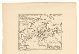
Canada orientale nell' America Settentrionale
8.
Carte d'une partie de l'Amérique Septentrionale : pour servir à l'intellegence du mémoire sur les prétentions des Anglois...
9.
A new map of Nova Scotia, and Cape Britain : with the adjacent parts of New England and Canada, composed from a great number of...
10.
Atlantic Ocean
11.
Chart comprizing Greenland with the countries and islands about Baffin's and Hudson's Bays
12.
Scandinavia
13.
Carte d'une partie de l'Amérique Septentrionale : pour servir à l'intellegence du mémoire sur les prétentions des anglois au...
14.
Carte reduite des costes orientales de l'Amerique septentrionale : 1re. feuille contenant L'Isle Royale, L'Accadie, La Baye...
15.
A chart of the sea coast of New Foundland, New Scotland, New England, New York, New Jersey, with Virginia and Maryland
16.
Karte von dem Ostlichen-Stucke von Neu Franckreich oder Canada in America : besonders aber Acadia und Neu Schottland
17.
A new map of Nova Scotia and Cape Breton Island : with the adjacent parts of New England and Canada composed from a great...
18.
A new map of Nova Scotia, and Cape Britain : with the adjacent parts of New England and Canada, composed from a great number of...
19.
Partie septentrionale des possessions Angloise en Amerique : pour servire d'intelligence à la guerre présente entre les...
20.
The 100th anniversary map of Abraham Lincoln's visit to Massachusetts, September 11-23, 1848
‹ Prev
Next ›
1
2
3
4
5
…
435
436