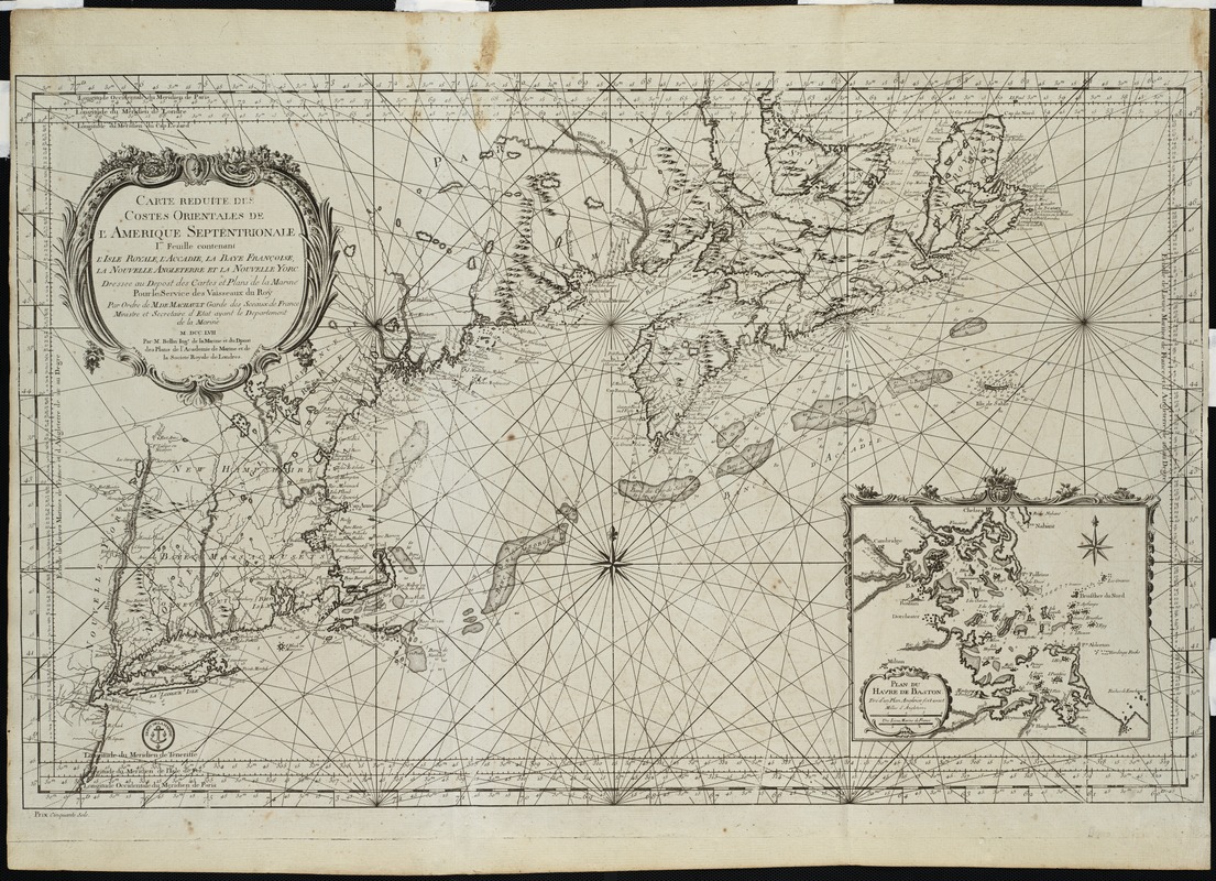
Carte reduite des costes orientales de l'Amerique septentrionale : 1re. feuille contenant L'Isle Royale, L'Accadie, La Baye Françoise, La Nouvelle Angleterre et La Nouvelle Yorc
This map is also available in American Revolutionary Geographies Online (ARGO), a collections portal especially built for material relating to the American Revolutionary War Era. Visit ARGO to learn more about this item and explore the historical geography of North America in the late eighteenth century.
Item Information
- Title:
- Carte reduite des costes orientales de l'Amerique septentrionale : 1re. feuille contenant L'Isle Royale, L'Accadie, La Baye Françoise, La Nouvelle Angleterre et La Nouvelle Yorc
- Description:
-
One of a series of French nautical charts covering the eastern coast of North America, this sheet covers the coast lines of New York, New England, Bay of Fundy, and Nova Scotia. The chart's only inset depicts Boston Bay and Harbor. This and other similar French charts were sold separately by the Depot de la Marine in Paris, but they were also bound into various editions of the two-volume Hydrographie françoise, published during the last half of the 19th century. Hydrographie françoise was a large composite atlas of charts compiled by Bellin, France's royal hydrographer.
- Creator:
- Bellin, Jacques Nicolas, 1703-1772
- Name on Item:
-
dressée au Depost des cartes et plans de la marine pour le service des vaisseaux du Roy ... M. DCC. LVVII par M. Bellin, ingr. de la marine et du Depost des plans, de l'Academie de marine, et de la Société Royale de Londres.
- Date:
-
[1757]
- Format:
-
Maps/Atlases
- Location:
- Private Collection
- Collection (local):
-
Mapping Boston Collection
- Subjects:
-
Nautical charts--Northeastern States--Early works to 1800
Nautical charts--Maritime Provinces--Early works to 1800
Northeastern States--Maps--Early works to 1800
Maritime Provinces--Maps--Early works to 1800
- Places:
-
Northeastern United States (area)
CanadaProvince of Prince Edward Island (province)
- Extent:
- 1 map ; 55 x 89 cm.
- Terms of Use:
-
No known copyright restrictions.
This work is licensed for use under a Creative Commons Attribution Non-Commercial Share Alike License (CC BY-NC-SA).

- Publisher:
-
Paris :
Dépôt des cartes et plans de la marine
- Scale:
-
Scale [ca. 1:1,800,000].
- Language:
-
French
- Notes:
-
Relief shown pictorially.
Depths shown by soundings.
Prime meridian: Paris.
"Par ordre de M. de Machault, Garde des Sceaux de France, Ministre et Secretaie d'etat ayant le Departement de la marine."
Inset: Plan du havre de Baston.
- Notes (date):
-
This date is inferred.
- Identifier:
-
06_01_001224
- Barcode:
-
39999052508395


