Toggle navigation
LMEC Home
Exhibitions
Georeferencing
Tools for Teachers
Collections
My Favorites
Sign Up / Log In
Search
Search the map portal
Map Collection
Map Collection
Map Sets
Search
Search
Search for
Search In
All Fields
Creator
Title
Subject
Place
Search All Digital Collections
Advanced Search
8740 Results
My Search
Start Over
More Like
commonwealth:js956j178
Remove constraint More Like: commonwealth:js956j178
Filter your Search
Place
North and Central America
5,971
United States
4,889
Massachusetts
2,080
Europe
1,396
Suffolk (county)
1,091
Boston
1,064
Canada
449
Asia
438
more
Place
»
Topic
Boston (Mass.)--Maps
588
United States--Maps
282
Real property--Massachusetts--Boston--Maps
186
Massachusetts--Maps
162
Landowners--Massachusetts--Boston--Maps
137
City planning--Massachusetts--Boston--Maps
105
North America--Maps--Early works to 1800
103
New England--Maps
102
more
Topic
»
Date
Date range begin
–
Date range end
Current results range from
1482
to
2023
View distribution
Creator
United States. Hydrographic Office
595
O.H. Bailey & Co
148
Des Barres, Joseph F. W. (Joseph Frederick Wallet), 1722-1824
123
United States. Post Office Dept
120
Boston Redevelopment Authority
107
Ptolemy, 2nd cent
100
Walling, Henry Francis, 1825-1888
94
Geological Survey (U.S.)
86
more
Creator
»
Format
Maps/Atlases
8,680
Manuscripts
215
Prints
56
Books
36
Objects/Artifacts
10
Drawings/Illustrations
8
Posters
5
Georeferenced
Yes
870
No
7,870
Collection
Norman B. Leventhal Map & Education Center Collection
8,696
Boston and New England Maps
2,274
Urban Maps
2,063
Maritime Charts and Atlases
1,083
American Revolutionary War-Era Maps
616
Boston Redevelopment Authority Collection
127
Massachusetts Real Estate Atlases
4
Applied Geographics, Inc. Records
1
more
Collection
»
Available to use
No known restrictions
8,593
Creative Commons license
48
Search Constraints
Sort by relevance
relevance
title
date (asc)
date (desc)
Number of results to display per page
20 per page
10
per page
20
per page
50
per page
100
per page
View results as:
grid view
map view
Search Results
7321.
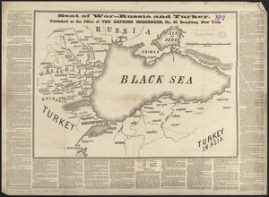
Seat of war--Russia and Turkey
7322.
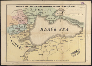
Seat of war--Russia and Turkey
7323.
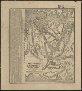
Sebastopol and Balaklava shewing the position of the allied forces
7324.
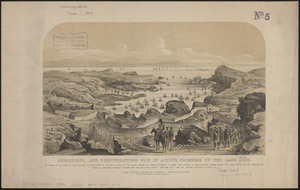
Sebastopol, and fortifications now in active progress on the land side
7325.
Second part of Asia : being China, part of India and Tartary, the islands of Sonda, Molucka, Philippin, Japan &c. ; performed...
7326.
The second section of the survey of 1819
7327.
Sect: Düsseldorf
7328.
Section 16: Chemnitz
7329.
Section 16: Chemnitz
7330.
Section of a track chart of the world, covering the Behring Sea
7331.
Sectional & topographical map of Holmes County, Ohio
7332.
A sectional map of Massachusetts, engraved expressly for Chapin's farm advertiser, 1871 : including the proposed Massachusetts...
7333.
Sectional map of the northern portion of Vancouver Island
7334.
Sectional map of the Old Colony Railroad South Shore, Nantasket Beach and Plymouth lines
7335.
Sections of soundings made by order of the Harbor Committee of 1852
7336.
Secunda Affrice tabula continet Affricam & insulae que circa ipsam sunt
7337.
Secunda Africae tabula
7338.
Secunda Asiae tabula
7339.
Secunda Asie tabula continet Sarmatia ipsius
7340.
Secunda Europae tabula
‹ Prev
Next ›
1
2
…
363
364
365
366
367
368
369
370
371
…
436
437