Toggle navigation
LMEC Home
Exhibitions
Georeferencing
Tools for Teachers
Collections
My Favorites
Sign Up / Log In
Search
Search the map portal
Map Collection
Map Collection
Map Sets
Search
Search
Search for
Search In
All Fields
Creator
Title
Subject
Place
Search All Digital Collections
Advanced Search
473 Results
My Search
Start Over
More Like
commonwealth:hx11xz975
Remove constraint More Like: commonwealth:hx11xz975
Filter your Search
Place
North and Central America
433
United States
312
Canada
118
New England
100
Essex (county)
24
Massachusetts
23
New York
23
Saint Lawrence River
23
more
Place
»
Topic
New England--Maps--Early works to 1800
97
United States--History--French and Indian War, 1754-1763--Maps, Manuscript--Early works to 1800
58
Middle Atlantic States--Maps--Early works to 1800
20
Louisbourg (N.S.)--Maps, Manuscript--Early works to 1800
18
Fort Edward (N.Y.)--Maps, Manuscript--Early works to 1800
16
Fort Ticonderoga (N.Y.)--Maps, Manuscript--Early works to 1800
15
Saint Lawrence River--Maps, Manuscript--Early works to 1800
15
Louisbourg (N.S.)--History--Siege, 1745--Maps, Manuscript--Early works to 1800
14
more
Topic
»
Date
Date range begin
–
Date range end
Current results range from
1617
to
1999
View distribution
Creator
Royal United Services Institute for Defence and Security Studies
160
George, III, King of Great Britain, 1738-1820
152
George, IV, King of Great Britain, 1762-1830
151
Amherst, Jeffery Amherst, Baron, 1717-1797
130
Skinner, Monier
28
Skinner, William, 1700-1780
28
Brasier, William
16
Bastide, John Henry, approximately 1700-1770
15
more
Creator
»
Format
Maps/Atlases
456
Manuscripts
151
Drawings/Illustrations
15
Georeferenced
Yes
15
No
458
Collection
American Revolutionary War-Era Maps
402
British Library Collection
376
Norman B. Leventhal Map & Education Center Collection
62
Boston and New England Maps
51
Mapping Boston Collection
23
Sidney R. Knafel Map Collection at Phillips Academy
15
Maritime Charts and Atlases
12
MacLean Collection Map Library
6
more
Collection
»
Available to use
Creative Commons license
410
No known restrictions
40
Search Constraints
Sort by relevance
relevance
title
date (asc)
date (desc)
Number of results to display per page
20 per page
10
per page
20
per page
50
per page
100
per page
View results as:
grid view
map view
Search Results
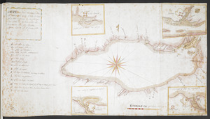
121.
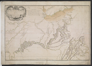
[A map showing the post route between the River St. Lawrence and the Bay of Fundy] : [on a scale of 5 1/3 miles to an inch.]
122.
[A map showing the post route between the River St. Lawrence and the Bay of Fundy] : [on a scale of 5 1/3 miles to an inch.]
123.
A, PLAN of the Ground Defined to be Fortified at OSWEGO
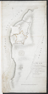
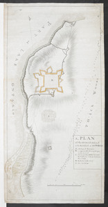
124.
A, PLAN of the Ground Defined to be Fortified at OSWEGO
125.
[A sketch map of the proposed battery (?) on Jekyll Island (?)]
126.
[Acadie, Isle Saint Jean and part of Isle Royale with the Baye Francoise]
127.
[Account of the action at Fort Niagara]
128.
[An outline plan of the harbour and fortifications of Louisbourg]
129.
[An unfinished chart of the Saint Lawrence River from Perrot Island to the Island of Orleans]
130.
BOWLES'S NEW POCKET MAP OF THE UNITED STATES OF AMERICA : WITH THE BRITISH POSSESSIONS OF CANADA, NOVA SCOTIA, AND OF...
131.
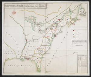
CANTONMENT of HIS MAJESTY'S FORCES in N. AMERICA ACCORDING TO THE DISPOSITION NOW MADE & TO BE COMPLETED AS SOON AS PRACTICABLE...
132.
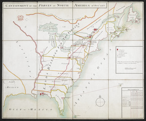
CANTONMENT OF THE FORCES IN NORTH AMERICA 11.th OCT.R 1765
133.
CARTE de la RIVIERE de KATARAKOUI : du cote du nord, qui donne la Connoissance des Chutes, Cascades, Troux, rapides, et mauvais...
134.
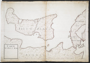
CARTE DE L'ISLE ST JEAN
135.
CARTE DU COURS DE L'OHIO OU DE LA BELLE RIVIERE : Depuis sa Source jusqu'a sa Jonction avec celle d'Ouabache, avec les pays les...
136.
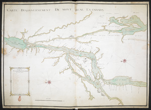
CARTE DU GOUVERNEMENT DE MONT REAL EN CANADA
137.
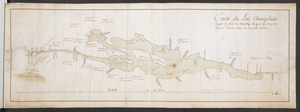
Carte du Lac Champlain depuis le Fort de Chambly Jusques au desus du Fort S.t Frederic, dans la Nouvelle France
138.
Carte Du Lac ontario nouvellement Rellevé avec ces port a grand pois a bitté Lescadre Engloisse & francoisse Leur gremant...
139.
Carte Nouvellement Releve de La presantation a Frontenac : Nee Les Soude & moulliage cett Rivier Est for courant depuis Les...
140.
CARTE, ou plan Nouveau du Lac Ontario, avec touttes les isles et bayes qui y Sont rénfermées : Et les forts qui Sont Scitués...
‹ Prev
Next ›
1
2
3
4
5
6
7
8
9
10
11
…
23
24
![[A map showing the post route between the River St. Lawrence and the Bay of Fundy]](https://bpldcassets.blob.core.windows.net/derivatives/images/commonwealth:hx11z4963/image_thumbnail_300.jpg)
![[A map showing the post route between the River St. Lawrence and the Bay of Fundy]](https://bpldcassets.blob.core.windows.net/derivatives/images/commonwealth:hx11z498n/image_thumbnail_300.jpg)
![[A sketch map of the proposed battery (?) on Jekyll Island (?)]](https://bpldcassets.blob.core.windows.net/derivatives/images/commonwealth:hx11z460q/image_thumbnail_300.jpg)
![[Acadie, Isle Saint Jean and part of Isle Royale with the Baye Francoise]](https://bpldcassets.blob.core.windows.net/derivatives/images/commonwealth:hx11z490f/image_thumbnail_300.jpg)
![[Account of the action at Fort Niagara]](https://bpldcassets.blob.core.windows.net/derivatives/images/commonwealth:6108vv66z/image_thumbnail_300.jpg)
![[An outline plan of the harbour and fortifications of Louisbourg]](https://bpldcassets.blob.core.windows.net/derivatives/images/commonwealth:hx11z5128/image_thumbnail_300.jpg)
![[An unfinished chart of the Saint Lawrence River from Perrot Island to the Island of Orleans]](https://bpldcassets.blob.core.windows.net/derivatives/images/commonwealth:hx11z0836/image_thumbnail_300.jpg)