Toggle navigation
LMEC Home
Exhibitions
Georeferencing
Tools for Teachers
Collections
My Favorites
Sign Up / Log In
Search
Search the map portal
Map Collection
Map Collection
Map Sets
Search
Search
Search for
Search In
All Fields
Creator
Title
Subject
Place
Search All Digital Collections
Advanced Search
9123 Results
My Search
Start Over
More Like
commonwealth:ht250q02z
Remove constraint More Like: commonwealth:ht250q02z
Filter your Search
Place
North and Central America
6,354
United States
5,270
Massachusetts
2,200
Suffolk (county)
1,469
Boston
1,442
Europe
1,396
Canada
449
Asia
438
more
Place
»
Topic
Boston (Mass.)--Maps
752
City planning--Massachusetts--Boston--Maps
418
United States--Maps
282
Urban renewal--Massachusetts--Boston--Maps
252
Real property--Massachusetts--Boston--Maps
225
Massachusetts--Maps
166
Landowners--Massachusetts--Boston--Maps
144
New England--Maps
104
more
Topic
»
Date
Date range begin
–
Date range end
Current results range from
1482
to
2023
View distribution
Creator
United States. Hydrographic Office
595
Boston Redevelopment Authority
398
O.H. Bailey & Co
148
Des Barres, Joseph F. W. (Joseph Frederick Wallet), 1722-1824
124
United States. Post Office Dept
120
Ptolemy, 2nd cent
100
Walling, Henry Francis, 1825-1888
94
Geological Survey (U.S.)
87
more
Creator
»
Format
Maps/Atlases
9,063
Manuscripts
215
Prints
56
Books
36
Objects/Artifacts
10
Drawings/Illustrations
8
Posters
5
Georeferenced
Yes
885
No
8,238
Collection
Norman B. Leventhal Map & Education Center Collection
8,723
Boston and New England Maps
2,619
Urban Maps
2,401
Maritime Charts and Atlases
1,083
American Revolutionary War-Era Maps
638
Boston Redevelopment Authority Collection
453
Mapping Boston Collection
20
Massachusetts Real Estate Atlases
12
more
Collection
»
Available to use
No known restrictions
8,926
Creative Commons license
70
Search Constraints
Sort by relevance
relevance
title
date (asc)
date (desc)
Number of results to display per page
20 per page
10
per page
20
per page
50
per page
100
per page
View results as:
grid view
map view
Search Results
7941.
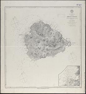
South Atlantic Ocean, Island of Ascension : republication of British Admiralty chart no. 1691, corrected to 1874
7942.
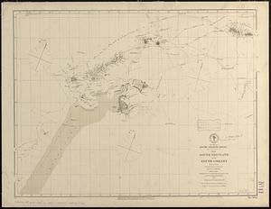
South Atlantic Ocean, the South Shetland and South Orkney Islands, with the tracks of the several discoverers, 1819 to 1843 :...
7943.
South Bay and Savin Hill parks : Dorchester district
7944.
South Boston
7945.
South Britain or England & Wales : drawn from several surveys &c. on the new projection ; corrected from astronomical...
7946.
South Carolina
7947.
South coast of Newfoundland, Great Miquelon Island, Miquelon Road : from a French survey in 1841
7948.
South coast of Newfoundland, St. Pierre Island, St. Pierre Harbor : from a French survey in 1841, with additions in 1881
7949.
The south east coast of Cape Breton Island
7950.
The south east coast of the island of St. John : surveyed under the direction of the Right Honourable the Lords of Trade and...
7951.
South Easton, Massachusetts : 1888
7952.
South end of Lake Huron and head of the St. Clair River
7953.
South end of Lake Michigan
7954.
A South Ender's view of the world
7955.
South entrance of Grand Passage : Cape St. Mary, N:E: one mile ; St. Mary's Bay
7956.
South extreme of America, Hermite Island, St. Martin Cove : from British surveys corrected to 1877
7957.
South extreme of America, Wollaston Islands : from British surveys corrected to 1878
7958.
South Framingham, Massachusetts
7959.
South Framingham, Massachusetts : 1882
7960.
South Germany, (Bavaria, &c.)
‹ Prev
Next ›
1
2
…
394
395
396
397
398
399
400
401
402
…
456
457