Toggle navigation
LMEC Home
Exhibitions
Georeferencing
Tools for Teachers
Collections
My Favorites
Sign Up / Log In
Search
Search the map portal
Map Collection
Map Collection
Map Sets
Search
Search
Search for
Search In
All Fields
Creator
Title
Subject
Place
Search All Digital Collections
Advanced Search
8162 Results
My Search
Start Over
More Like
commonwealth:ht2501963
Remove constraint More Like: commonwealth:ht2501963
Filter your Search
Place
North and Central America
4,912
United States
3,602
Suffolk (county)
1,026
Boston
999
Europe
962
Canada
427
France
269
Massachusetts
249
more
Place
»
Topic
Boston (Mass.)--Maps
574
United States--Maps
270
Real property--Massachusetts--Boston--Maps
174
Massachusetts--Maps
160
Landowners--Massachusetts--Boston--Maps
132
North America--Maps--Early works to 1800
103
New England--Maps
99
Europe--Maps
78
more
Topic
»
Date
Date range begin
–
Date range end
Current results range from
1482
to
2023
View distribution
Creator
United States. Hydrographic Office
357
O.H. Bailey & Co
148
Des Barres, Joseph F. W. (Joseph Frederick Wallet), 1722-1824
123
United States. Post Office Dept
120
Ptolemy, 2nd cent
100
Walling, Henry Francis, 1825-1888
94
Jefferys, Thomas, -1771
84
Geological Survey (U.S.)
82
more
Creator
»
Format
Maps/Atlases
8,103
Manuscripts
215
Prints
51
Books
36
Objects/Artifacts
10
Drawings/Illustrations
8
Posters
4
Georeferenced
Yes
869
No
7,293
Collection
Norman B. Leventhal Map Center Collection
8,162
Boston and New England Maps
2,184
Urban Maps
1,924
Maritime Charts and Atlases
750
American Revolutionary War-Era Maps
616
Boston Redevelopment Authority Collection
86
Available to use
No known restrictions
8,021
Creative Commons license
46
Search Constraints
Sort by relevance
relevance
title
date (asc)
date (desc)
Number of results to display per page
20 per page
10
per page
20
per page
50
per page
100
per page
View results as:
grid view
map view
Search Results
1.
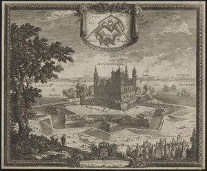
Delineatio arcis Cronenburgensis quam sereniss. rex Sueciae amplioribus munimentis cingere fecit A. 1659
2.
Accurata delineatio oppugnatae a faederatis, Caesareis, Polonicis, Danicis, et Brandeburgicis copijs sub-ductu Seren: Electoris...
3.
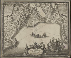
Delineatio urbis Nidrosiae vulgo, Dronheem in Norvegia, à Danis d. 28. Septem. obsessae et 11. Decemb. deditione capta an. 1658
4.
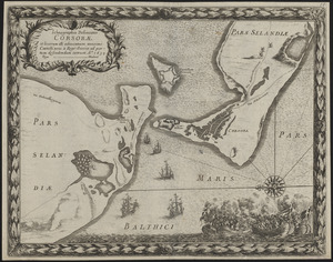
Ichnographia delineatio Corsorae et locorum illi adiacentium maximè Castelli novi à Rege Sueciae ad portum defendendum...
5.
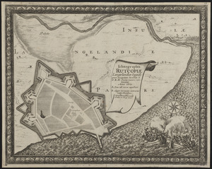
Ichnographia Rutcopiae Langelandiae oppidi post occupatam insulam à S.R.M. Sveciae muniri continuatae anno 1659
6.
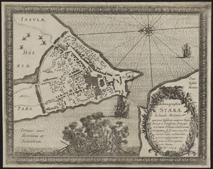
Ichnographia Staekae in insula Moënia : quae post insulam auspicio Regis Sueciae à Celsissimo Principe et Comite Palatino...
7.
Nackschouia Lalandiae oppidum, quod praesidio 1600 Danorum munitu sine ullo conflictu S. R. M. Sueciae arbitrio se permisit. 8....
8.
The 100th anniversary map of Abraham Lincoln's visit to Massachusetts, September 11-23, 1848
9.
1630 shoreline
10.
1879. Progress map of the U.S. Geographical Surveys west of the 100th Meridian : prepared under the direction of 1st Lieut....
11.
1903 Map of Salem and surrounding places
12.
19th annual convention of the National Association of Real Estate Boards : at Tulsa, June 7 to June 11 in 1926
13.
2005 significant U.S. hurricane strikes
14.
The 2100 project : an atlas for the Green New Deal
15.
227 Harzgerode
16.
305 Glatz
17.
38,000,000 escaped -- 10,000,000 died
18.
4 Kinten
19.
660 Wakulah St., Roxbury
20.
[A chart of Boston Bay and vicinity]
‹ Prev
Next ›
1
2
3
4
5
…
408
409


![[A chart of Boston Bay and vicinity]](https://bpldcassets.blob.core.windows.net/derivatives/images/commonwealth:cj82m2976/image_thumbnail_300.jpg)