Toggle navigation
LMEC Home
Exhibitions
Georeferencing
Tools for Teachers
Collections
My Favorites
Sign Up / Log In
Search
Search the map portal
Map Collection
Map Collection
Map Sets
Search
Search
Search for
Search In
All Fields
Creator
Title
Subject
Place
Search All Digital Collections
Advanced Search
181 Results
My Search
Start Over
More Like
commonwealth:hq37vv940
Remove constraint More Like: commonwealth:hq37vv940
Filter your Search
Place
North and Central America
138
New England
93
United States
43
Middle Atlantic
35
Massachusetts
22
Canada
15
New York
15
Northeastern United States
12
more
Place
»
Topic
New England--Maps--Early works to 1800
91
Middle Atlantic States--Maps--Early works to 1800
36
World maps--Early works to 1800
13
Northeastern States--Maps--Early works to 1800
12
North America--Maps--Early works to 1800
11
Massachusetts--Maps--Early works to 1800
10
New York (State)--Maps--Early works to 1800
10
America--Maps--Early works to 1800
9
more
Topic
»
Date
Date range begin
–
Date range end
Current results range from
1482
to
1999
View distribution
Creator
Jefferys, Thomas, -1771
8
Jefferys, Thomas, d. 1771
8
Bellin, Jacques Nicolas, 1703-1772
5
Lodge, John, -1796
5
Ortelius, Abraham, 1527-1598
5
Sayer, Robert, 1725-1794
5
Green, John, d. 1757
4
Bew, John, -1793
3
more
Creator
»
Format
Maps/Atlases
181
Manuscripts
2
Books
1
Georeferenced
Yes
19
No
162
Collection
Sidney R. Knafel Map Collection at Phillips Academy
87
American Revolutionary War-Era Maps
75
Norman B. Leventhal Map Center Collection
71
Boston and New England Maps
30
Mapping Boston Collection
24
Maritime Charts and Atlases
13
Richard H. Brown Revolutionary War Map Collection at Mount Vernon
8
New York Public Library Collection
6
more
Collection
»
Available to use
No known restrictions
48
Creative Commons license
44
Search Constraints
Sort by relevance
relevance
title
date (asc)
date (desc)
Number of results to display per page
100 per page
10
per page
20
per page
50
per page
100
per page
View results as:
grid view
map view
Search Results
101.
Pas-caert van Terra Nova, Nova Francia, Nieuw-Engeland en de groote rivier van Canada
102.
Pascaerte van Terra Nova Nova Francia Nievw Engeland En de Groote Revier van Canada
103.
Pas-kaart vande zee kusten inde boght van Niew Engeland : tusschen de staaten Hoek en C. de Sable
104.
Plan des jenigen treffen welches am 8. Sept 1755. zwischen dem Engl. Gen. Johnson, und dem Franz. Gen. Diesckau welcher dabey...
105.
Schauplatz des Kriegs zwischen Engelland und seinen Collonien in America
106.
The seat of war, in New England, by an American volunteer : with the marches of the several corps sent by the colonies, towards...
107.
The south part of New England as it planted this yeare, 1634
108.
The south part of New England, as it planted this yeare, 1639
109.
An accurate map of the English colonies in North America, bordering on the river Ohio
110.
America
111.
America sive India Nova : ad magnae Gerardi Mercatoris aui universalis imitationem in compendium redacta
112.
America sive novvs orbis respectv Evropaeorvm inferior globi terrestris pars
113.
Americae pars Borealis, Florida, Baccalaos, Canada, Corterealis
114.
Americae siue noui orbis, noua descriptio
115.
Americae siue noui orbis, noua descriptio
116.
The American Atlas or, A Geographical Description of the whole continent of America : wherein are delineated at large, its...
117.
The American pilot : containing the navigation of the sea coat of North America . . .
118.
Atlantic Ocean
119.
L'Atlas de mer ou monde aquatique, remontrant toutes les côtes de la mer, a scavoir de la partie connuë de I'Univers, avec une...
120.
Barnstable County, Dukes County and Nantucket Island, Massachusetts
121.
Baye et port d'Yorc, capitale de la Nouvelle Yorc
122.
Carta marina nova tabula
123.
Chart and plan of the harbour of New York & the couny. adjacent, from Sandy Hook to Kingsbridge, comprehending the whole of New...
124.
A chart of the gulf stream
125.
Costes et rivieres de Virginie, de Mariland, et de Nouvelle Angletere
126.
The English pilot. The fourth book. Describing the West-India navigation, from Hudson's-Bay to the River Amazones. Particulary...
127.
Garden of Eden
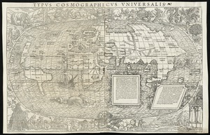
128.
Generale Ptholemei
129.
Geological map of Massachusetts
130.
The harbor of Holmes' Hole
131.
Herbipolis occidens Wurtzpurg
132.
La heroike enterprinse faict par le Signeur Draeck d'avoir cirquit toute la terre
133.
A map of Massachusetts, from the best authorities
134.
Map of Massachusetts, from the best authorities
135.
A map of the British and French dominions in North America with the roads, distances, limits, and extent of the settlements,...
136.
Map of the Caribbean Area
137.
Map of the northern part of New England : compiled for Pres't. Dwight's travels
138.
A map of the province of Massachusets Bay and colony of Rhode Island, with part of Connecticut, New Hampshire, and Vermont
139.
Map of the southern part of New England : compiled for Pres't. Dwights travels
140.
Maris Pacifici (quod vulgo Mar del Zur) cum regionibus circumiacentibus, insulisque in eodem passim sparsis, novissima descriptio
141.
Massachusetts
142.
Massachusetts
143.
Massachusetts
144.
Massachusetts and Rhode Island
145.
A new and accurate map of the colony of Massachusets Bay, in North America, from a late survey
146.
New Englands prospect : A true, lively, and experimentall description of that part of America, commonly called New England:...
147.
The north part of America : conteyning Newfoundland, new England, Virginia, Florida, new Spaine, and Noua Francia wth ye rich...
148.
Nova, et integra universi orbis descriptio
149.
Novae insulae XVII, nova tabula
150.
Oceani occidetalis seu terre nove tabula
151.
Old Colony & Newport railway and its connections
152.
Old Colony Railroad and connections
153.
Orbis terrae compendiosa descriptio : quam ex magna universali Gerardi Mercatoris Domino Richardo Gartho, geographie ac...
154.
Orbis typus uniuersalis iuxta hydrographorum traditionem
155.
Oval map of the world
156.
Pars Prima. Speculum Nauticum super navigatione maris Occidentalis confectum, continens omnes oras maritimas Gallia, Hispaniae...
157.
Part of east New Jarsey, New York, and Connecticut
158.
Partie de la carte du Capitaine Cluny, auteur d'un ouvrage anglois intitulé American Traveller publié à Londres en 1769
159.
Pascaert van Nieu Nederland van Hendrick Christiaens Eijland tot staten hoeck of Cabo Cod
160.
Porti della Nuova York e Perthamboy
161.
Praeclara Ferna[n]di Cortesii de Noua maris Oceani Hyspania Narratio . . .
162.
Preliminary sketch showing the positions of Davis' Shoal and other dangers recently discovered by the Coast Survey and the...
163.
Quarte partie du monde
164.
Scandinavia
165.
Secunda etas mundi = Secunda etas mũdi
166.
Septentrionalium terrarum descriptio
167.
Sketch A No. 5 showing proposed site for a light house on Sow and Pigs Reef
168.
Sketch A showing the progress of the survey in section no. 1 from 1844 to 1881
169.
The state of Massachusetts
170.
The state of Massachusetts from the best information
171.
Terra de Lavoratore
172.
Theatro del mondo di Abrahamo Ortelio : da lui poco inanzi la sua morte riueduto, & di tauole nuoue, et commenti adorno, &...
173.
Tipus orbis uniuersalis iuxta Ptolomei cosmographi traditionem et Americi Vespucii alior[um]que
174.
Typus cosmographicus uniuersalis
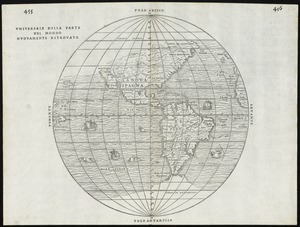
175.
Typus orbis terrarum
176.
Universale della parte del mondo nuovamente ritrovata
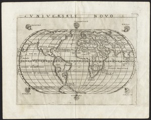
177.
Universale novo
178.
Universalis de terrao orarium ex vera recen [...] traditione
179.
Virginia et Nova Francia
180.
The world
181.
World map
‹ Prev
Next ›
1
2