Typus cosmographicus uniuersalis
Item Information
- Title:
- Typus cosmographicus uniuersalis
- Title (alt.):
-
Typvs cosmographicvs vniversalis
Typus cosmographicus universalis
- Description:
-
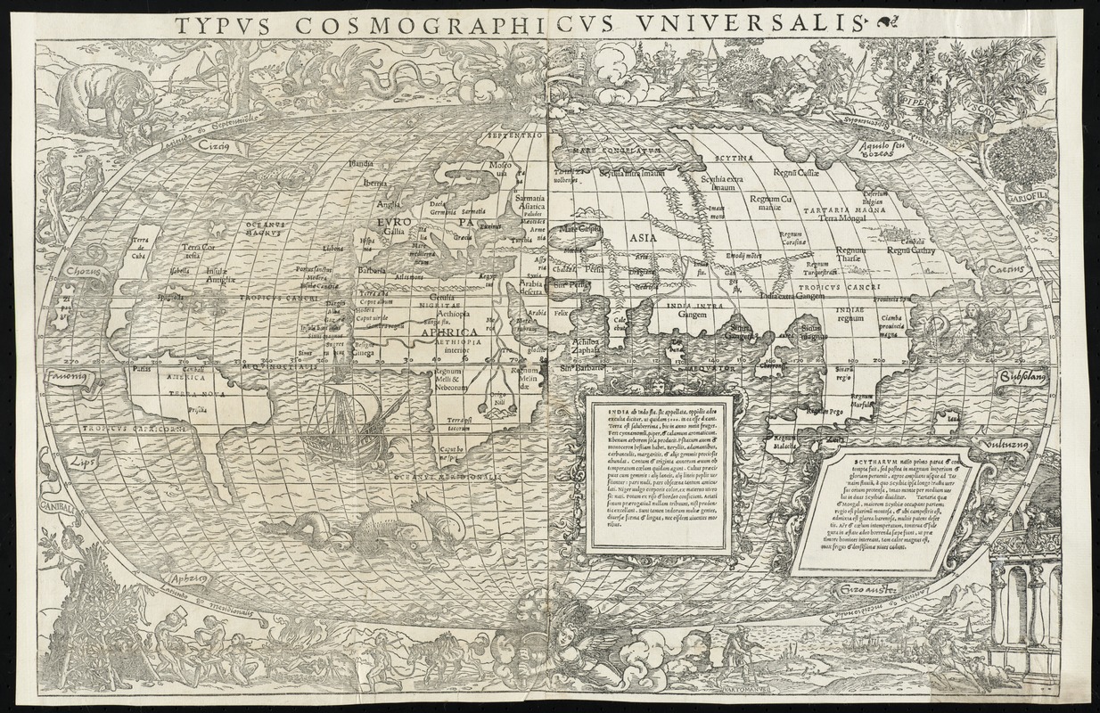
Decorated with sea monsters, mermaids, exotic animals, and cannibals, this wood cut map provides a marked contrast to the simplistic diagrams considered the earliest printed world maps. While the latter presented a world view based in Judeo-Christian theology, this uniquely ornamented map emphasized the strange and fanciful discoveries emanating from European explorations in America, Africa, and Asia. Most likely prepared by the geographer Sebastian Münster and decorated by the artist Hans Holbien the Younger, this map illustrated the Basel edition of Novus Orbis Regionum, a collection of early voyage accounts, first published in 1532 and republished in 1555. The French edition of the same book (also published in 1532) included Oronce Fine's double cordiform map). Underscoring Europeans' dilemma during the first quarter of the 16th century in rationalizing the New World discoveries, Münster's map followed the model of Waldseemüller and Apianus showing the New World discoveries as a separate continent named America placed between two distinctly separate oceans. Fine's map was more ambiguous, showing a fairly accurately delineated America, but attached to the Asian mainland in the northern latitudes.
- Contributor:
- Holbein, Hans, 1497?-1543
- Creator:
- Münster, Sebastian, 1489-1552
- Name on Item:
-
[Sebastian Münster, Hans Holbein]
- Date:
-
1532
- Format:
-
Maps/Atlases
- Location:
- Phillips Academy
- Collection (local):
-
Sidney R. Knafel Map Collection at Phillips Academy, Andover MA
- Subjects:
-
World maps--Early works to 1800
- Extent:
- 1 map ; 40 x 55 cm.
- Terms of Use:
-
Rights status not evaluated.
Contact host institution for more information.
- Publisher:
-
Basel :
[s.n.]
- Scale:
-
Scale [ca .1:35,000,000]
- Language:
-
Latin
- Notes:
-
Relief shown pictorially.
Appears in Johann Huttich's Novus orbis regionum. Basel. 1532.
- Notes (citation):
-
Shirley, R.W. Mapping of the world, 67
- Notes (exhibitions):
-
Exhibited: "Journeys of the Imagination" organized by the Norman B. Leventhal Map Center at the Boston Public Library, 2006.
- Identifier:
-
1343


