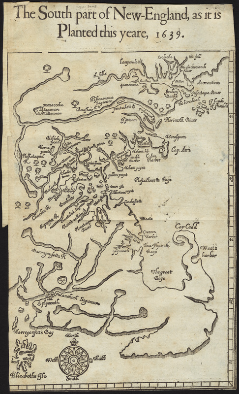
The south part of New England, as it planted this yeare, 1639
Item Information
- Title:
- The south part of New England, as it planted this yeare, 1639
- Creator:
- Wood, William, active 1629-1635
- Cartographer:
- Wood, William, active 1629-1635
- Contributor:
- Dawson, John, -1648?
- Contributor:
- Bellamie, John, -1654
- Date:
-
[1639]
- Format:
-
Maps/Atlases
- Location:
- Private Collection
- Collection (local):
-
Mapping Boston Collection
- Subjects:
-
Massachusetts--Maps--Early works to 1800
New England--Maps--Early works to 1800
- Places:
-
Massachusetts
- Extent:
- 1 map ; 27 x 18 cm
- Terms of Use:
-
No known copyright restrictions.
This work is licensed for use under a Creative Commons Attribution Non-Commercial Share Alike License (CC BY-NC-SA).

- Publisher:
-
[London] :
[Printed by Iohn Dawson, and are to be sold by Iohn Bellamy]
- Scale:
-
Scale approximately 1:1,150,000
- Language:
-
English
- Notes:
-
From Woods' New England prospect (London : Printed by Iohn Dawson, and are to be sold by Iohn Bellamy at his shop, 1639).
- Notes (date):
-
This date is inferred.
- Identifier:
-
06_01_001237
- Barcode:
-
39999085930533


![[Map of eastern Massachusetts and vicinity]](https://bpldcassets.blob.core.windows.net/derivatives/images/commonwealth:9s161d29f/image_thumbnail_300.jpg)

