Toggle navigation
LMEC Home
Exhibitions
Georeferencing
Tools for Teachers
Collections
My Favorites
Sign Up / Log In
Search
Search the map portal
Map Collection
Map Collection
Map Sets
Search
Search
Search for
Search In
All Fields
Creator
Title
Subject
Place
Search All Digital Collections
Advanced Search
8776 Results
My Search
Start Over
More Like
commonwealth:6t053p36k
Remove constraint More Like: commonwealth:6t053p36k
Filter your Search
Place
North and Central America
6,007
United States
4,917
Massachusetts
2,092
Europe
1,396
Suffolk (county)
1,048
Boston
1,021
Canada
458
Asia
438
more
Place
»
Topic
Boston (Mass.)--Maps
587
United States--Maps
282
Real property--Massachusetts--Boston--Maps
175
Massachusetts--Maps
162
Landowners--Massachusetts--Boston--Maps
133
North America--Maps--Early works to 1800
106
New England--Maps
102
New England--Maps--Early works to 1800
97
more
Topic
»
Date
Date range begin
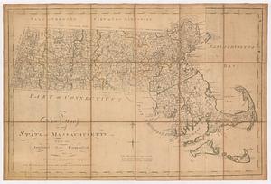
–
Date range end
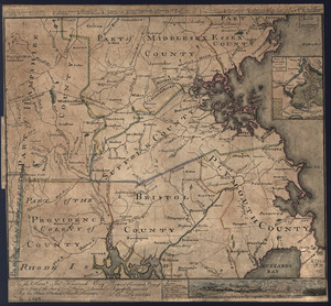
Current results range from
1482
to
2023
View distribution
Creator
United States. Hydrographic Office
595
O.H. Bailey & Co
148
Des Barres, Joseph F. W. (Joseph Frederick Wallet), 1722-1824
123
United States. Post Office Dept
120
Ptolemy, 2nd cent
100
Walling, Henry Francis, 1825-1888
94
Jefferys, Thomas, -1771
88
Geological Survey (U.S.)
86
more
Creator
»
Format
Maps/Atlases
8,716
Manuscripts
219
Prints
56
Books
36
Objects/Artifacts
10
Drawings/Illustrations
8
Posters
5
Georeferenced
Yes
876
No
7,900
Collection
Norman B. Leventhal Map & Education Center Collection
8,720
Boston and New England Maps
2,246
Urban Maps
2,023
Maritime Charts and Atlases
1,086
American Revolutionary War-Era Maps
665
Boston Redevelopment Authority Collection
87
Mapping Boston Collection
24
Sidney R. Knafel Map Collection at Phillips Academy
20
more
Collection
»
Available to use
No known restrictions
8,555
Creative Commons license
92
Search Constraints
Sort by relevance
relevance
title
date (asc)
date (desc)
Number of results to display per page
20 per page
10
per page
20
per page
50
per page
100
per page
View results as:
grid view
map view
Search Results
61.
Pas caerte van Nieu Nederlandt en de Engelsche Virginies van Cabo Cod tot Cabo Canrick
62.
Pas-caert van Terra Nova, Nova Francia, Nieuw-Engeland en de groote rivier van Canada
63.
Pascaerte van Terra Nova Nova Francia Nievw Engeland En de Groote Revier van Canada
64.
Combat naval à la hauteur de la Baye de Chézapeake [sic] le 5 7bre. 1781
65.
Connecticut
66.
Connecticut and parts adjacent
67.
Connecticut and parts adjacent
68.
Part of east New Jarsey, New York, and Connecticut
69.
To the right honourable, the Earl of Shelbourne, His Majesty's principal Secretary of State for the Southern Department : this...
70.
Rhode Island
71.
An accurate map of the country round Boston in New England from the best authorities
72.
A Copy of the Plan returned by his Maj:tys Com:rs for setling the Boundarys between the Provinces of New Hampshire and the...
73.
A map of Massachusetts, from the best authorities
74.
A Map Of the River MERRIMACK from the Atlantick Ocean to Pantuckett Falls describing bounds between His Maj:tys Province of New...
75.
A new map of the state of Massachusetts : from the original map compiled by Osgood Carleton esq.r from the actual surveys that...
76.
A PLAN of the Rivers and Boundary Lines referr'd to in ye Proceedings & Judgment of ye Commissioners for adjusting the Bounds...
77.
The state of Massachusetts
78.
The state of Massachusetts from the best information
79.
To the Hone. Jno. Hancock, Esqre. president of ye Continental Congress, this map of the seat of civil war in America, is...
80.
To the Hone. Jno. Hancock, Esqre. president of ye Continental Congress, this map of the seat of civil war in America, is...
‹ Prev
Next ›
1
2
3
4
5
6
7
8
…
438
439


![Combat naval à la hauteur de la Baye de Chézapeake [sic] le 5 7bre. 1781](https://bpldcassets.blob.core.windows.net/derivatives/images/commonwealth:z603vn12t/image_thumbnail_300.jpg)