Toggle navigation
LMEC Home
Exhibitions
Georeferencing
Tools for Teachers
Collections
My Favorites
Sign Up / Log In
Search
Search the map portal
Map Collection
Map Collection
Map Sets
Search
Search
Search for
Search In
All Fields
Creator
Title
Subject
Place
Search All Digital Collections
Advanced Search
8718 Results
My Search
Start Over
More Like
commonwealth:4m90fd842
Remove constraint More Like: commonwealth:4m90fd842
Filter your Search
Place
North and Central America
5,949
United States
4,862
Massachusetts
2,079
Europe
1,396
Suffolk (county)
1,046
Boston
1,019
Canada
449
Asia
438
more
Place
»
Topic
Boston (Mass.)--Maps
586
United States--Maps
282
Real property--Massachusetts--Boston--Maps
175
Massachusetts--Maps
162
Landowners--Massachusetts--Boston--Maps
133
North America--Maps--Early works to 1800
103
New England--Maps
102
Europe--Maps
79
more
Topic
»
Date
Date range begin
–
Date range end
Current results range from
1482
to
2023
View distribution
Creator
United States. Hydrographic Office
595
O.H. Bailey & Co
148
Des Barres, Joseph F. W. (Joseph Frederick Wallet), 1722-1824
123
United States. Post Office Dept
120
Ptolemy, 2nd cent
100
Walling, Henry Francis, 1825-1888
94
Geological Survey (U.S.)
86
Jefferys, Thomas, -1771
86
more
Creator
»
Format
Maps/Atlases
8,658
Manuscripts
215
Prints
56
Books
36
Objects/Artifacts
10
Drawings/Illustrations
8
Posters
5
Georeferenced
Yes
869
No
7,849
Collection
Norman B. Leventhal Map & Education Center Collection
8,695
Boston and New England Maps
2,233
Urban Maps
2,023
Maritime Charts and Atlases
1,083
American Revolutionary War-Era Maps
639
Boston Redevelopment Authority Collection
87
William L. Clements Library Collection
17
American Antiquarian Society Collection
5
more
Collection
»
Available to use
No known restrictions
8,553
Creative Commons license
47
Search Constraints
Sort by relevance
relevance
title
date (asc)
date (desc)
Number of results to display per page
20 per page
10
per page
20
per page
50
per page
100
per page
View results as:
grid view
map view
Search Results
41.
Fort Monroe and vicinity showing entrance to Chesapeake Bay, Norfolk, Portsmouth, Gosport Navy Yard &c
42.
Lloyd's official map of the state of Virginia from actual surveys by order of the Executive, 1828 & 1859
43.
Map of eastern Virginia
44.
Map of eastern Virginia
45.
Map of n. eastern Virginia and vicinity of Washington
46.
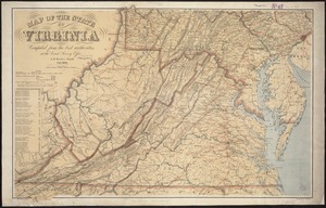
Map of the State of Virginia
47.
Map of the vicinity of Yorktown, Virginia, 1881
48.
Map of Virginia and Maryland, constructed from the latest authorities
49.
Middle Virginia and North Carolina
50.
The new war map of Virginia, Maryland & Pennsylvania
51.
Official map of the state of Virginia : from actual surveys by order of the executive, 1828 & 1859
52.
Scarborough's new county and post office map of Virginia, Maryland, Delaware, and District of Columbia : with complete index...
53.
The seat of war : birds eye view of Virginia, Maryland, Delaware, and the District of Columbia
54.
Seat of war in Virginia and Maryland
55.
Smith's topographical map of Virginia and Maryland
56.
State of Virginia : stations and transmission lines used in public service in 1925 and gaging stations
57.
State of Virginia coal fields and producing districts, September 1919
58.
The tourist's pocket map of the state of Virginia : exhibiting its internal improvements, roads, distances &c
59.
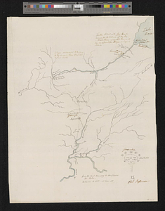
Action between Genl. St Clairs army & that of the American Indians Novr. 4th 1791 : collected from his public letter
60.
Campaign of Major General Anthony Wayne, 1793-94
‹ Prev
Next ›
1
2
3
4
5
6
7
…
435
436