Official map of the state of Virginia : from actual surveys by order of the executive, 1828 & 1859
Item Information
- Title:
- Official map of the state of Virginia : from actual surveys by order of the executive, 1828 & 1859
- Description:
-
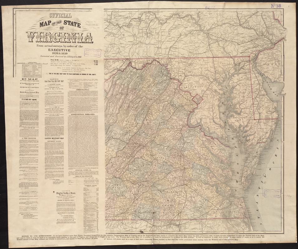
At the beginning of the war, few detailed topographic maps were available to officers for planning movements and engagements. In addition, some moderate-scale state maps, which could be used for planning broader regional strategies, were out-of-date. This was especially true for Virginia, where many of the battles were fought. Although this 1861 Virginia map claims to be official, accurate and current, the title is misleading. It was not an official state publication; rather it was produced by a commercial firm located in New York City. It was derived from an 1859 state map, which was a hurried revision of an earlier 1828 state map. The latter map did incorporate county surveys, but they were inconsistent in scale and data collected.
- Creator:
- Lloyd, James T.
- Name on Item:
-
Corrected and revised by J.T. Lloyd to 1861.
- Date:
-
[1861]
- Format:
-
Maps/Atlases
- Location:
-
Boston Public Library
Norman B. Leventhal Map & Education Center - Collection (local):
-
Norman B. Leventhal Map & Education Center Collection
- Subjects:
-
Virginia--Maps
Maryland--Maps
- Places:
-
Virginia
Maryland
- Extent:
- 1 map : col. ; 75 x 62 cm, on sheet 82 x 98 cm
- Terms of Use:
-
No known copyright restrictions.
No known restrictions on use.
- Publisher:
-
New York :
J.T. Lloyd
- Edition:
- Corrected and revised by J.T. Lloyd to 1861
- Scale:
-
Scale [ca. 1:650,000].
- Language:
-
English
- Notes:
-
Indicates forts, batteries, "places remarkable for military incidents," roads, distances, railroads, towns, mills, factories, boundaries and drainage.
Covers eastern Virginia and Maryland.
Relief shown by hachures.
"N.B.: This is the only map used to plan campaigns in Virginia by Gen. Scott."
Prime meridian: Washington.
"Notice" along bottom margin: " ... the valuable topographical map of Virginia ... engraver has been unable to complete the whole map before the 26th of October, 1861 ... The western half of this map will be printed and ready for publication on or before the 26th proximo."
Includes publisher's advertisements, text, and tables for population, steamboat routes, and altitudes to left of map.
- Notes (date):
-
This date is inferred.
- Notes (exhibitions):
-
Exhibited: "Torn in Two: The 150th Anniversary of the Civil War" organized by the Norman B. Leventhal Map Center at the Boston Public Library, 2011.
- Identifier:
-
06_01_006849
- Call #:
-
G3880 1861 .L46
- Barcode:
-
39999059028686
- LCCN:
-
98686952


