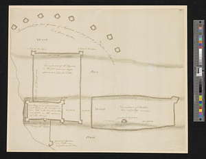
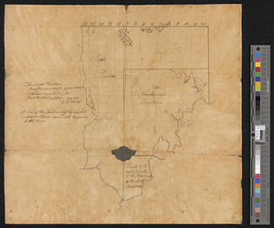
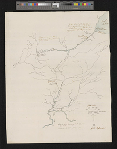
Campaign of Major General Anthony Wayne, 1793-94
This map is also available in American Revolutionary Geographies Online (ARGO), a collections portal especially built for material relating to the American Revolutionary War Era. Visit ARGO to learn more about this item and explore the historical geography of North America in the late eighteenth century.
Item Information
- Title:
- Campaign of Major General Anthony Wayne, 1793-94
- Title (alt.):
-
Greenville Fort Jefferson
- Contributor:
- Simcoe, Elizabeth, 1762-1850
- Creator:
- Simcoe, John Graves, 1752-1806
- Date:
-
[1794]
- Format:
-
Maps/Atlases
- Genre:
-
Manuscript maps
- Location:
- William L. Clements Library
- Collection (local):
-
William L. Clements Library Collection
- Subjects:
-
Wayne's Campaign, 1794--Maps
Ohio--Maps
Fort Greenville (Ohio)--Maps
- Places:
-
Ohio
- Extent:
- 1 ms. map : col. ; 40.7 x 31.4 cm.
- Terms of Use:
-
The University of Michigan Library provides access to these materials for educational and research purposes. These materials may be under copyright. If you decide to use any of these materials, you are responsible for making your own legal assessment and securing any necessary permission. If you have questions about the collection, please contact the William L. Clements Library.
Contact host institution for more information.
- Scale:
-
Scale ca. 1:1,267,200.
- Language:
-
English
- Catalog Record:
-
Catalog record
- Notes:
-
Finished, colored, topographical, pen and ink map of the Miami and Maumee valleys of Ohio and Indiana showing forts constructed by the Americans.
Map updated in another hand to show events of Wayne's 1794 campaign.
Map attributed to John Graves Simcoe, but possibly by Elizabeth Simcoe.
Clinton Maps 347.
- Notes (date):
-
This date is inferred.
- Identifier:
-
912
- Barcode:
-
B1938595