Toggle navigation
LMEC Home
Exhibitions
Georeferencing
Tools for Teachers
Collections
My Favorites
Sign Up / Log In
Search
Search the map portal
Map Collection
Map Collection
Map Sets
Search
Search
Search for
Search In
All Fields
Creator
Title
Subject
Place
Search All Digital Collections
Advanced Search
8162 Results
My Search
Start Over
More Like
commonwealth:4m90f9151
Remove constraint More Like: commonwealth:4m90f9151
Filter your Search
Place
North and Central America
4,911
United States
3,743
Suffolk (county)
1,026
Boston
999
Europe
963
Canada
427
Massachusetts
294
France
269
more
Place
»
Topic
Boston (Mass.)--Maps
574
United States--Maps
270
Real property--Massachusetts--Boston--Maps
174
Massachusetts--Maps
160
Landowners--Massachusetts--Boston--Maps
132
North America--Maps--Early works to 1800
103
New England--Maps
99
Europe--Maps
78
more
Topic
»
Date
Date range begin
–
Date range end
Current results range from
1482
to
2023
View distribution
Creator
United States. Hydrographic Office
357
O.H. Bailey & Co
148
Des Barres, Joseph F. W. (Joseph Frederick Wallet), 1722-1824
123
United States. Post Office Dept
120
Ptolemy, 2nd cent
100
Walling, Henry Francis, 1825-1888
94
Jefferys, Thomas, -1771
84
Geological Survey (U.S.)
82
more
Creator
»
Format
Maps/Atlases
8,103
Manuscripts
215
Prints
51
Books
36
Objects/Artifacts
10
Drawings/Illustrations
8
Posters
4
Georeferenced
Yes
869
No
7,293
Collection
Norman B. Leventhal Map Center Collection
8,162
Boston and New England Maps
2,184
Urban Maps
1,924
Maritime Charts and Atlases
750
American Revolutionary War-Era Maps
616
Boston Redevelopment Authority Collection
86
Available to use
No known restrictions
8,021
Creative Commons license
46
Search Constraints
Sort by relevance
relevance
title
date (asc)
date (desc)
Number of results to display per page
20 per page
10
per page
20
per page
50
per page
100
per page
View results as:
grid view
map view
Search Results
1.
Map of Cincinnati, Covington & Newport
2.
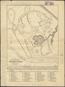
Ground plan of the Zoological Garden of Cincinnati, O
3.
The 100th anniversary map of Abraham Lincoln's visit to Massachusetts, September 11-23, 1848
4.
1630 shoreline
5.
1879. Progress map of the U.S. Geographical Surveys west of the 100th Meridian : prepared under the direction of 1st Lieut....
6.
1903 Map of Salem and surrounding places
7.
19th annual convention of the National Association of Real Estate Boards : at Tulsa, June 7 to June 11 in 1926
8.
2005 significant U.S. hurricane strikes
9.
The 2100 project : an atlas for the Green New Deal
10.
227 Harzgerode
11.
305 Glatz
12.
38,000,000 escaped -- 10,000,000 died
13.
4 Kinten
14.
660 Wakulah St., Roxbury
15.
[A chart of Boston Bay and vicinity]
16.
[A chart of New York Island & North River : East River, passage through Hell Gate, Flushing Bay, Hampstead Bay, Oyster,...
17.
The A.A.A. key road map of continental Europe
18.
Aaron Bohrod's America, its history
19.
ABC pathfinder railway guide map : eastern division
20.
Abolition of Slavery, 1863
‹ Prev
Next ›
1
2
3
4
5
…
408
409


![[A chart of Boston Bay and vicinity]](https://bpldcassets.blob.core.windows.net/derivatives/images/commonwealth:cj82m2976/image_thumbnail_300.jpg)


