Toggle navigation
LMEC Home
Exhibitions
Georeferencing
Tools for Teachers
Collections
My Favorites
Sign Up / Log In
Search
Search the map portal
Map Collection
Map Collection
Map Sets
Search
Search
Search for
Search In
All Fields
Creator
Title
Subject
Place
Search All Digital Collections
Advanced Search
8648 Results
My Search
Start Over
More Like
commonwealth:3f462z24z
Remove constraint More Like: commonwealth:3f462z24z
Filter your Search
Place
North and Central America
5,886
United States
4,805
Massachusetts
2,068
Europe
1,392
Suffolk (county)
1,041
Boston
1,014
Canada
449
Asia
437
more
Place
»
Topic
Boston (Mass.)--Maps
582
United States--Maps
279
Real property--Massachusetts--Boston--Maps
175
Massachusetts--Maps
161
Landowners--Massachusetts--Boston--Maps
133
North America--Maps--Early works to 1800
103
New England--Maps
101
Europe--Maps
79
more
Topic
»
Date
Date range begin
–
Date range end
Current results range from
1482
to
2023
View distribution
Creator
United States. Hydrographic Office
595
O.H. Bailey & Co
148
Des Barres, Joseph F. W. (Joseph Frederick Wallet), 1722-1824
123
United States. Post Office Dept
120
Ptolemy, 2nd cent
100
Walling, Henry Francis, 1825-1888
94
Geological Survey (U.S.)
86
Jefferys, Thomas, -1771
85
more
Creator
»
Format
Maps/Atlases
8,588
Manuscripts
216
Prints
56
Books
36
Objects/Artifacts
10
Drawings/Illustrations
8
Posters
5
Georeferenced
Yes
869
No
7,779
Collection
Norman B. Leventhal Map & Education Center Collection
8,646
Boston and New England Maps
2,221
Urban Maps
1,992
Maritime Charts and Atlases
1,083
American Revolutionary War-Era Maps
617
Boston Redevelopment Authority Collection
87
Newberry Library Collection
1
Richard H. Brown Revolutionary War Map Collection at Mount Vernon
1
Available to use
No known restrictions
8,504
Creative Commons license
48
Search Constraints
Sort by relevance
relevance
title
date (asc)
date (desc)
Number of results to display per page
20 per page
10
per page
20
per page
50
per page
100
per page
View results as:
grid view
map view
Search Results
1.
A chart of the Streights of Bell Isle
2.
Chart of the streights of Belle Isle
3.
Chart of the Streights of Belle Isle
4.
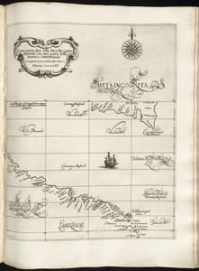
Carta particolare della Meta Incognita Australe con una parte della America Settentrionale
5.
Carta particolare della terra nuoua con la Gran Baia et il Fiume Grande della Canida
6.
A chart of the banks and part of the coast of Newfoundland including the islands of Sable and Cape Breton
7.
A chart of the banks and part of the coast of Newfoundland including the islands of Sable and Cape Breton
8.
A chart of the Banks of Newfoundland, drawn from a great number of hydrographical surveys, chiefly from those of Chabert, Cook...
9.
Plan du detroit de Belle Isle et du Golphe St. Laurent pour la coste du nord
10.
Chart of the Banks of Newfoundland, drawn from a great number of hydrographical surveys, these charts are followed, according...
11.
The 100th anniversary map of Abraham Lincoln's visit to Massachusetts, September 11-23, 1848
12.
1630 shoreline
13.
1879. Progress map of the U.S. Geographical Surveys west of the 100th Meridian : prepared under the direction of 1st Lieut....
14.
1903 Map of Salem and surrounding places
15.
19th annual convention of the National Association of Real Estate Boards : at Tulsa, June 7 to June 11 in 1926
16.
2005 significant U.S. hurricane strikes
17.
The 2100 project : an atlas for the Green New Deal
18.
227 Harzgerode
19.
305 Glatz
20.
38,000,000 escaped -- 10,000,000 died
‹ Prev
Next ›
1
2
3
4
5
…
432
433