Toggle navigation
LMEC Home
Exhibitions
Georeferencing
Tools for Teachers
Collections
My Favorites
Sign Up / Log In
Search
Search the map portal
Map Collection
Map Collection
Map Sets
Search
Search
Search for
Search In
All Fields
Creator
Title
Subject
Place
Search All Digital Collections
Advanced Search
8951 Results
My Search
Start Over
More Like
commonwealth:1257c3871
Remove constraint More Like: commonwealth:1257c3871
Filter your Search
Place
North and Central America
6,182
United States
5,098
Massachusetts
2,145
Europe
1,396
Suffolk (county)
1,297
Boston
1,270
Canada
449
Asia
438
more
Place
»
Topic
Boston (Mass.)--Maps
753
United States--Maps
282
Real property--Massachusetts--Boston--Maps
254
City planning--Massachusetts--Boston--Maps
213
Landowners--Massachusetts--Boston--Maps
170
Massachusetts--Maps
166
Urban renewal--Massachusetts--Boston--Maps
114
New England--Maps
104
more
Topic
»
Date
Date range begin
–
Date range end
Current results range from
1482
to
2023
View distribution
Creator
United States. Hydrographic Office
595
Boston Redevelopment Authority
217
O.H. Bailey & Co
148
Des Barres, Joseph F. W. (Joseph Frederick Wallet), 1722-1824
124
United States. Post Office Dept
120
Ptolemy, 2nd cent
100
Walling, Henry Francis, 1825-1888
94
Geological Survey (U.S.)
87
more
Creator
»
Format
Maps/Atlases
8,891
Manuscripts
215
Prints
56
Books
36
Objects/Artifacts
10
Drawings/Illustrations
8
Posters
5
Georeferenced
Yes
885
No
8,066
Collection
Norman B. Leventhal Map & Education Center Collection
8,725
Boston and New England Maps
2,421
Urban Maps
2,205
Maritime Charts and Atlases
1,083
American Revolutionary War-Era Maps
638
Boston Redevelopment Authority Collection
253
Massachusetts Real Estate Atlases
38
Mapping Boston Collection
20
more
Collection
»
Available to use
No known restrictions
8,728
Creative Commons license
70
Search Constraints
Sort by relevance
relevance
title
date (asc)
date (desc)
Number of results to display per page
20 per page
10
per page
20
per page
50
per page
100
per page
View results as:
grid view
map view
Search Results
781.
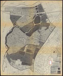
Parker Hill-Fenway urban renewal area r-48 : existing land use
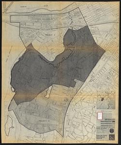
782.
Parker Hill-Fenway urban renewal area r-48 : development areas
783.
Parker Hill-Fenway urban renewal area r-48 : proposed title I projects
784.
Wastewater system map, Boston proper, sheet no. 21h
785.
Water distribution system map, Boston proper, sheet no. 21h
786.
Water distribution system map, Boston proper, sheet no. 22h
787.
Water system map, Boston proper, sheet no. 22h
788.
1975 general land use plan
789.
An accurate plan of the town of Boston and its vicinity : exhibiting a ground plan of all the streets, lanes, alleys, wharves,...
790.
Atlas of Massachusetts
791.
Atlas of Massachusetts
792.
Boston
793.
Boston
794.
Boston
795.
Boston and adjacent cities
796.
Boston and its environs
797.
Boston and surroundings
798.
Boston bikemap : toward intelligent commuting
799.
Boston I
800.
Boston II
‹ Prev
Next ›
1
2
…
36
37
38
39
40
41
42
43
44
…
447
448