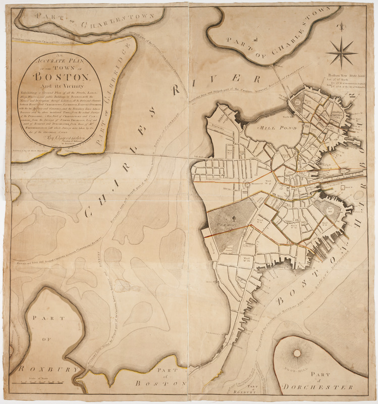
An accurate plan of the town of Boston and its vicinity : exhibiting a ground plan of all the streets, lanes, alleys, wharves, and public buildings in Boston, with the names and description thereof, likewise all the flats and channels between Boston and Charlestown, Cambridge, Roxbury & Dorchester with the two bridges and causeway, and the boundary lines beween Boston and the above mentioned towns, from the actual surveys of the publisher: : also part of Charlestown and Cambridge, from the surveys of Samuel Thompson, Esqr. and part of Roxbury and Dorchester, from those of Mr. Whitherington, (all which surveys were taken by order of the General Court.)
This map is also available in American Revolutionary Geographies Online (ARGO), a collections portal especially built for material relating to the American Revolutionary War Era. Visit ARGO to learn more about this item and explore the historical geography of North America in the late eighteenth century.
Item Information
- Title:
- An accurate plan of the town of Boston and its vicinity : exhibiting a ground plan of all the streets, lanes, alleys, wharves, and public buildings in Boston, with the names and description thereof, likewise all the flats and channels between Boston and Charlestown, Cambridge, Roxbury & Dorchester with the two bridges and causeway, and the boundary lines beween Boston and the above mentioned towns, from the actual surveys of the publisher: : also part of Charlestown and Cambridge, from the surveys of Samuel Thompson, Esqr. and part of Roxbury and Dorchester, from those of Mr. Whitherington, (all which surveys were taken by order of the General Court.)
- Description:
-
Subject: Map of the city of Boston, with parts of Roxbury, Dorchester and Cambridge. Some roads and areas are colored in watercolor. Some public buildings are named.
- Creator:
- Carleton, Osgood, 1742-1816
- Publisher:
- Carleton, Osgood, 1742-1816
- Publisher:
- Norman, William, -1807
- Engraver:
- Norman, John, 1748?-1817
- Name on Item:
-
By Osgood Carleton teacher of mathematics in Boston. ; I. Norman sc.
- Date:
-
[1797]
- Format:
-
Maps/Atlases
- Location:
- American Antiquarian Society
- Collection (local):
-
American Antiquarian Society Collection
- Subjects:
-
Boston (Mass.)--Maps
- Places:
-
MassachusettsSuffolk (county)Boston
- Extent:
- 1 map on 6 sheets : engraving, hand colored ; 104 x 96 cm., on sheets 36 x 50 cm., or smaller
- Terms of Use:
-
Public Domain/No known restrictions on use. Contact host institution to download image.
Contact host institution for more information.
- Publisher:
-
[Boston] :
Published & sold by O. Carleton sold also by Wm. Norman no. 75 Newbury Street.
- Scale:
-
Scale [ca. 1:4,170]
- Language:
-
English
- Catalog Record:
-
http://catalog.mwa.org/vwebv/holdingsInfo?bibId=476387
- Notes:
-
Relief shown by hachures.
"Published as the act directs May 16, 1797."
- Notes (date):
-
This date is inferred.
![[Chart of Boston Harbor and the surrounding areas]](https://bpldcassets.blob.core.windows.net/derivatives/images/commonwealth:6108vs71d/image_thumbnail_300.jpg)


