Toggle navigation
LMEC Home
Exhibitions
Georeferencing
Tools for Teachers
Collections
My Favorites
Sign Up / Log In
Search
Search the map portal
Map Collection
Map Collection
Map Sets
Search
Search
Search for
Search In
All Fields
Creator
Title
Subject
Place
Search All Digital Collections
Advanced Search
8803 Results
My Search
Start Over
More Like
commonwealth:1257bc71m
Remove constraint More Like: commonwealth:1257bc71m
Filter your Search
Place
North and Central America
6,034
United States
4,952
Massachusetts
2,118
Europe
1,396
Suffolk (county)
1,154
Boston
1,127
Canada
449
Asia
438
more
Place
»
Topic
Boston (Mass.)--Maps
607
United States--Maps
282
Real property--Massachusetts--Boston--Maps
253
Landowners--Massachusetts--Boston--Maps
170
Massachusetts--Maps
162
City planning--Massachusetts--Boston--Maps
133
North America--Maps--Early works to 1800
103
New England--Maps
102
more
Topic
»
Date
Date range begin
–
Date range end
Current results range from
1482
to
2023
View distribution
Creator
United States. Hydrographic Office
595
O.H. Bailey & Co
148
Boston Redevelopment Authority
135
Des Barres, Joseph F. W. (Joseph Frederick Wallet), 1722-1824
123
United States. Post Office Dept
120
Ptolemy, 2nd cent
100
Walling, Henry Francis, 1825-1888
94
Geological Survey (U.S.)
86
more
Creator
»
Format
Maps/Atlases
8,742
Manuscripts
215
Prints
56
Books
36
Objects/Artifacts
10
Drawings/Illustrations
9
Posters
5
Georeferenced
Yes
870
No
7,933
Collection
Norman B. Leventhal Map & Education Center Collection
8,697
Boston and New England Maps
2,303
Urban Maps
2,092
Maritime Charts and Atlases
1,083
American Revolutionary War-Era Maps
620
Boston Redevelopment Authority Collection
155
Massachusetts Real Estate Atlases
35
William L. Clements Library Collection
3
more
Collection
»
Available to use
No known restrictions
8,621
Creative Commons license
49
Search Constraints
Sort by relevance
relevance
title
date (asc)
date (desc)
Number of results to display per page
20 per page
10
per page
20
per page
50
per page
100
per page
View results as:
grid view
map view
Search Results
4081.
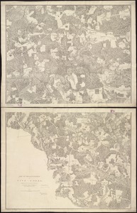
Map of the battlefield of Five-Forks
4082.
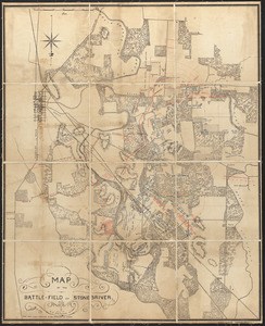
Map of the battle-field of Stone's-River
4083.
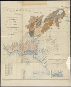
Map of the Bering River Coal Field : showing distribution of the various kinds of coal and location of the coal sections and...
4084.
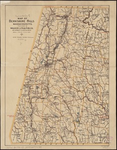
Map of the Berkshire Hills Massachusetts
4085.
A map of the Bermuda Islands : ya des demonios, isles of the devils
4086.
Map of the Beverly and Manchester shore Massachusetts
4087.
Map of the Black Hills from a reconnaissance by Capt. William Ludlow, Corps of Engineers, 1874, and maps of Warren and Raynolds
4088.
Map of the borough of Princeton, Mercer County, New Jersey
4089.
Map of the borough, of Stonington, Connecticut, 1851
4090.
Map of the Boston & Maine Railroad, showing its relative position & connection with other railroads
4091.
Map of the Boston and Northwestern, Massachusetts Central, and Boston and Poughkeepsie Railroads and their connections
4092.
Map of the Boston, Concord, Montreal & White Mountains Railroad and its principal connections
4093.
Map of the Boston Elevated Ry. 1915
4094.
Map of the Boston Elevated Ry. 1927
4095.
Map of the Boston Metropolitan District showing park reservations and holdings of the Metropolitan District Commission and...
4096.
Map of the Boston-Worcester century run
4097.
Map of the boundary lines between the United States and the adjacent British provinces from the mouth of the River St. Croix to...
4098.
A Map of the British American plantations, extending from Boston in New England to Georgia : including all the back settlements...
4099.
A map of the British and French dominions in North America : with the roads, distances, limits, and extent of the settlements,...
4100.
A map of the British and French dominions in North America : with the roads, distances, limits, and extent of the settlements,...
‹ Prev
Next ›
1
2
…
201
202
203
204
205
206
207
208
209
…
440
441