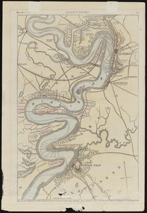
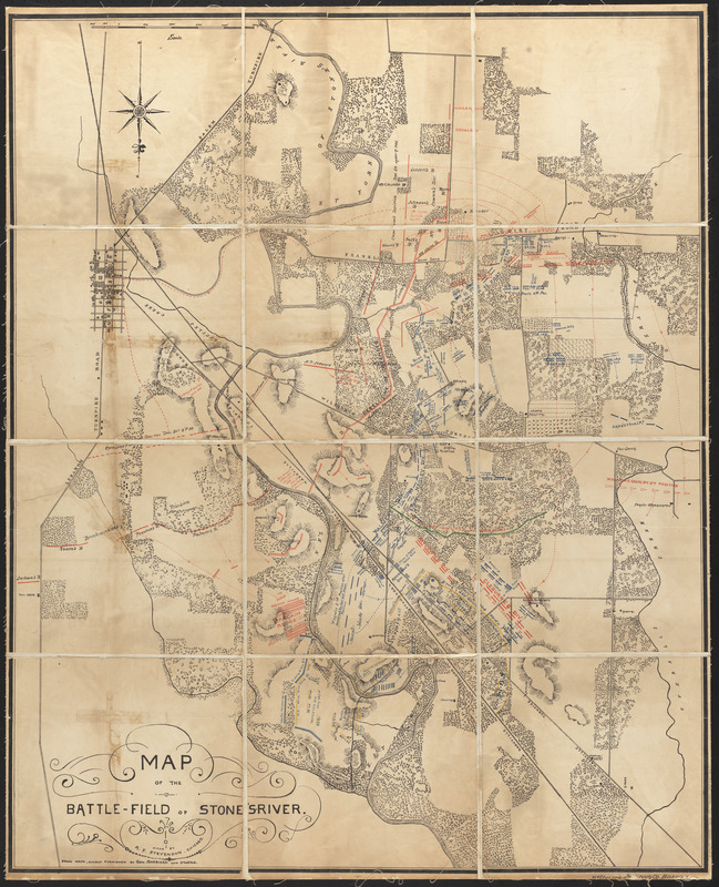
Map of the battle-field of Stone's-River
Item Information
- Title:
- Map of the battle-field of Stone's-River
- Cartographer:
- Stevenson, Alexander F.
- Publisher:
- James R. Osgood and Company
- Printer:
- Heliotype Printing Co.
- Name on Item:
-
made by A.F. Stevenson, Chicago, from maps kindly furnished by Gen. Sheridan and others
- Date:
-
[1884]
- Format:
-
Maps/Atlases
- Location:
-
Boston Public Library
Norman B. Leventhal Map & Education Center - Collection (local):
-
Norman B. Leventhal Map & Education Center Collection
- Subjects:
-
Stones River, Battle of, Murfreesboro, Tenn., 1862-1863--Maps
United States--History--Civil War, 1861-1865
- Places:
-
TennesseeRutherford (county)Murfreesboro
- Extent:
- 1 map : color ; 88 x 71 cm
- Terms of Use:
-
No known copyright restrictions.
No known restrictions on use.
- Publisher:
-
[Boston] :
[J.R. Osgood and Co.]
- Scale:
-
Scale approximately 1:11,000
- Language:
-
English
- Notes:
-
Shows troop positions, movements and engagements.
Relief shown by hachures.
Oriented with north to the bottom.
From: The battle of Stone's River near Murfreesboro', Tenn. December 30, 1862, to January 3, 1863 / Alexander F. Stevenson. Boston : J.R. Osgood, 1884.
- Notes (date):
-
This date is inferred.
- Identifier:
-
06_01_016139
- Call #:
-
G3964.M9S5 1884 .S7
- Barcode:
-
39999085943437