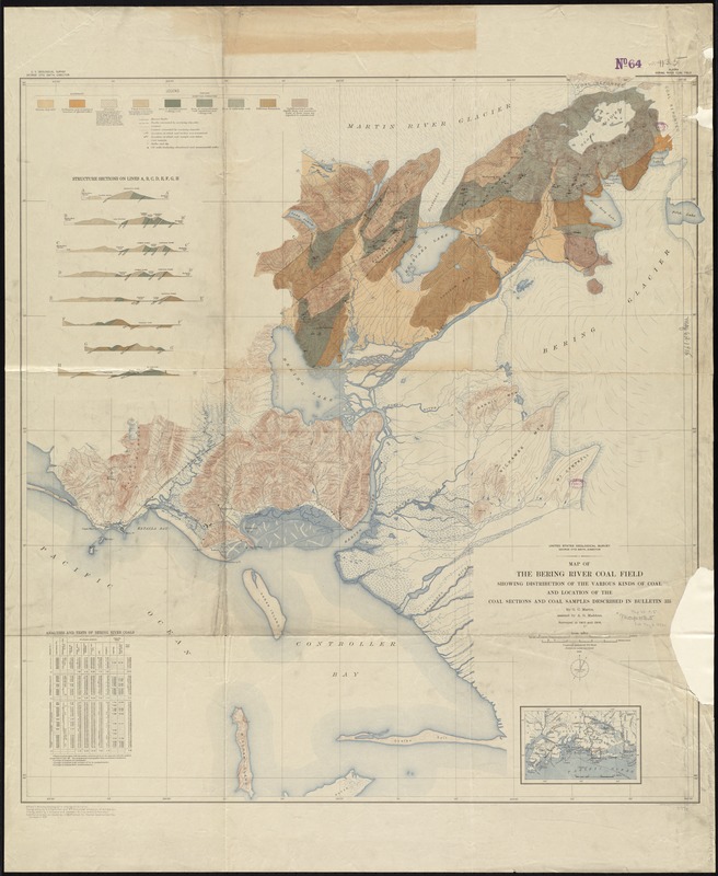
Map of the Bering River Coal Field : showing distribution of the various kinds of coal and location of the coal sections and coal samples described in Bulletin 335
Item Information
- Title:
- Map of the Bering River Coal Field : showing distribution of the various kinds of coal and location of the coal sections and coal samples described in Bulletin 335
- Title in upper right margin :
- Alaska, Bering River Coal Field
- Title (alt.) :
- Bering River Coal Field
- Creator:
- Martin, G. C. (George Curtis), 1875-1943
- Name on Item:
-
by G.C. Martin ; assisted by A.G. Maddren.
- Date:
-
1915
- Format:
-
Maps/Atlases
- Location:
-
Boston Public Library
Norman B. Leventhal Map & Education Center - Collection (local):
-
Norman B. Leventhal Map & Education Center Collection
- Subjects:
-
Coal--Alaska--Bering River--Maps
Coal--Alaska--Controller Bay--Maps
Geology--Alaska--Bering River--Maps
Geology--Alaska--Controller Bay--Maps
Bering River Region (Alaska)--Maps
Controller Bay Region (Alaska)--Maps
- Places:
-
AlaskaChugach (area)Bering River
AlaskaChugach (area)Controller Bay
- Extent:
- 1 map : col. ; 93 x 88 cm.
- Terms of Use:
-
No known copyright restrictions.
No known restrictions on use.
- Publisher:
-
[Washington, D.C.] :
United States Geological Survey
- Scale:
-
Scale 1:62,500
- Language:
-
English
- Notes:
-
Map extends from Controller Bay north to the Martin River Glacier.
Relief shown by contours and spot heights.
"Surveyed in 1905 and 1906."
"Alfred H. Brooks, Geologist in charge of division. Typography by E.G. Hamilton and W.R. Hill ; under direction of G.C. Martin."--Lower left margin.
Includes location map, 8 geologic cross sections, and chart of "Analyses and tests of Bering River coals."
Geologic map of the coal field described in: Geology and mineral resources of the Controller Bay region, Alaska / by G.C. Martin. Washington : G.P.O., 1908.
- Identifier:
-
06_01_011398
- Call #:
-
G4372.B47H9 1915 .M37
- Barcode:
-
39999065684050


