Toggle navigation
LMEC Home
Exhibitions
Georeferencing
Tools for Teachers
Collections
My Favorites
Sign Up / Log In
Search
Search the map portal
Map Collection
Map Collection
Map Sets
Search
Search
Search for
Search In
All Fields
Creator
Title
Subject
Place
Search All Digital Collections
Advanced Search
8721 Results
My Search
Start Over
More Like
commonwealth:0z709425w
Remove constraint More Like: commonwealth:0z709425w
Filter your Search
Place
North and Central America
5,949
United States
4,864
Massachusetts
2,079
Europe
1,396
Suffolk (county)
1,047
Boston
1,019
Canada
450
Asia
438
more
Place
»
Topic
Boston (Mass.)--Maps
586
United States--Maps
282
Real property--Massachusetts--Boston--Maps
175
Massachusetts--Maps
162
Landowners--Massachusetts--Boston--Maps
133
North America--Maps--Early works to 1800
103
New England--Maps
102
Manuscript maps
84
more
Topic
»
Date
Date range begin
–
Date range end
Current results range from
1482
to
2023
View distribution
Creator
United States. Hydrographic Office
595
O.H. Bailey & Co
148
Des Barres, Joseph F. W. (Joseph Frederick Wallet), 1722-1824
123
United States. Post Office Dept
120
Ptolemy, 2nd cent
100
Walling, Henry Francis, 1825-1888
94
Geological Survey (U.S.)
86
Jefferys, Thomas, -1771
85
more
Creator
»
Format
Maps/Atlases
8,661
Manuscripts
241
Prints
56
Books
36
Objects/Artifacts
10
Drawings/Illustrations
8
Posters
5
Georeferenced
Yes
869
No
7,852
Collection
Norman B. Leventhal Map & Education Center Collection
8,699
Boston and New England Maps
2,233
Urban Maps
2,023
Maritime Charts and Atlases
1,083
American Revolutionary War-Era Maps
640
Boston Redevelopment Authority Collection
87
Library of Congress Collection
22
Available to use
No known restrictions
8,554
Creative Commons license
72
Search Constraints
Sort by relevance
relevance
title
date (asc)
date (desc)
Number of results to display per page
20 per page
10
per page
20
per page
50
per page
100
per page
View results as:
grid view
map view
Search Results
81.
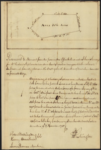
Survey of land for Richard Stephenson in Frederick County; attested by Robert Worthington, Henry Bradshaw and Lewis Thomas : recto
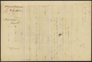
82.
Survey of land for Richard Stephenson in Frederick County; attested by Robert Worthington, Henry Bradshaw and Lewis Thomas : verso
83.
The world
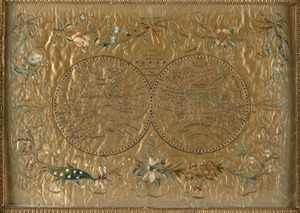
84.
The world with all the modern discoveries
85.
The 100th anniversary map of Abraham Lincoln's visit to Massachusetts, September 11-23, 1848
86.
1630 shoreline
87.
1879. Progress map of the U.S. Geographical Surveys west of the 100th Meridian : prepared under the direction of 1st Lieut....
88.
1903 Map of Salem and surrounding places
89.
19th annual convention of the National Association of Real Estate Boards : at Tulsa, June 7 to June 11 in 1926
90.
2005 significant U.S. hurricane strikes
91.
The 2100 project : an atlas for the Green New Deal
92.
227 Harzgerode
93.
305 Glatz
94.
38,000,000 escaped -- 10,000,000 died
95.
4 Kinten
96.
660 Wakulah St., Roxbury
97.
74 miles on the ocean scenic highway U.S. 1
98.
[A chart of Boston Bay and vicinity]
99.
[A chart of New York Island & North River : East River, passage through Hell Gate, Flushing Bay, Hampstead Bay, Oyster,...
100.
The A.A.A. key road map of continental Europe
‹ Prev
Next ›
1
2
3
4
5
6
7
8
9
…
436
437


![[A chart of Boston Bay and vicinity]](https://bpldcassets.blob.core.windows.net/derivatives/images/commonwealth:cj82m2976/image_thumbnail_300.jpg)

