Toggle navigation
LMEC Home
Exhibitions
Georeferencing
Tools for Teachers
Collections
My Favorites
Sign Up / Log In
Search
Search the map portal
Map Collection
Map Collection
Map Sets
Search
Search
Search for
Search In
All Fields
Creator
Title
Subject
Place
Search All Digital Collections
Advanced Search
8742 Results
My Search
Start Over
More Like
commonwealth:0z709278h
Remove constraint More Like: commonwealth:0z709278h
Filter your Search
Place
North and Central America
5,973
United States
4,862
Massachusetts
2,079
Europe
1,396
Suffolk (county)
1,046
Boston
1,019
Canada
477
Asia
438
more
Place
»
Topic
Boston (Mass.)--Maps
586
United States--Maps
282
Real property--Massachusetts--Boston--Maps
175
Massachusetts--Maps
163
Landowners--Massachusetts--Boston--Maps
133
New England--Maps
106
North America--Maps--Early works to 1800
103
Europe--Maps
79
more
Topic
»
Date
Date range begin
–
Date range end
Current results range from
1482
to
2023
View distribution
Creator
United States. Hydrographic Office
595
O.H. Bailey & Co
148
Des Barres, Joseph F. W. (Joseph Frederick Wallet), 1722-1824
123
United States. Post Office Dept
120
Ptolemy, 2nd cent
100
Walling, Henry Francis, 1825-1888
94
Geological Survey (U.S.)
90
Jefferys, Thomas, -1771
85
more
Creator
»
Format
Maps/Atlases
8,682
Manuscripts
218
Prints
56
Books
36
Objects/Artifacts
10
Drawings/Illustrations
8
Posters
5
Georeferenced
Yes
869
No
7,873
Collection
Norman B. Leventhal Map & Education Center Collection
8,699
Boston and New England Maps
2,238
Urban Maps
2,023
Maritime Charts and Atlases
1,083
American Revolutionary War-Era Maps
657
Boston Redevelopment Authority Collection
87
William L. Clements Library Collection
22
American Antiquarian Society Collection
9
more
Collection
»
Available to use
No known restrictions
8,557
Creative Commons license
49
Search Constraints
Sort by relevance
relevance
title
date (asc)
date (desc)
Number of results to display per page
20 per page
10
per page
20
per page
50
per page
100
per page
View results as:
grid view
map view
Search Results
7501.
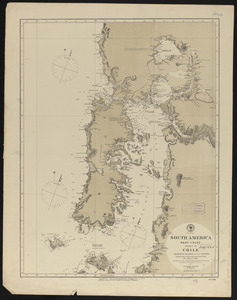
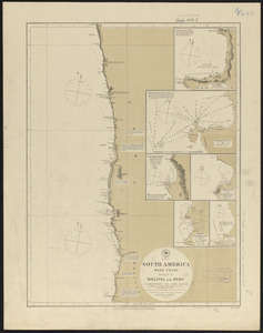
South America, west coast : republication of Brit. Admiralty chart no. 1289, with additions to 1876
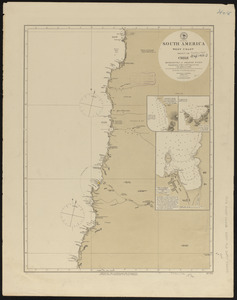
7502.
South America, west coast : republication of Brit. Admty. chart no. 1276, with additions to 1876
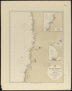
7503.
South America, west coast : republication of Brit. Admty. chart no. 1282, with additions to 1876
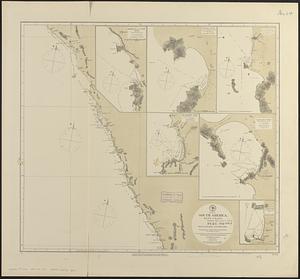
7504.
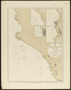
South America, west coast : republication of Brit. Admty. chart no. 1285, with additions to 1877
7505.
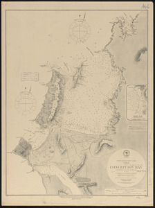
South America-- west coast, Chile, Concepcion Bay : from British and French surveys
7506.
South America, west coast, Chile, Coronel, Lota & Colcura anchorages in Arauco Bay : from a Chilean government survey in 1878
7507.
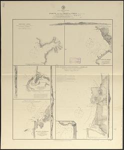
South America, west coast, Chile, ports on the coast of Chile : special plans to chart no. 753 : from surveys by Capt. Pomar...
7508.
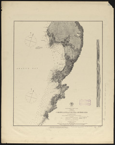
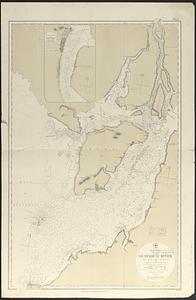
South America, west coast, Ecuador, Guayaquil River : from a British survey in 1847, corrected to 1876 ; republication of Brit....
7509.
South America, west coast, harbors on the coast of Ecuador : from British surveys in 1837 and 1847 ; republication of Brit....
7510.
South America, west coast, harbors on the coast of New Granada : special plans to chart no. 766
7511.
South America, west coast, Nueva Granada, Port Buenaventura : from a British survey in 1846 ; republication of Brit. Admty....
7512.
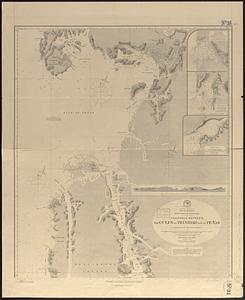
South America, west coast of Patagonia, channels between Magellan Strait and the Gulf of Trinidad : compiled from the most...
7513.
South America, west coast of Patagonia, channels between the Gulfs of Trinidad and of Peñas : compiled from the most recent...
7514.
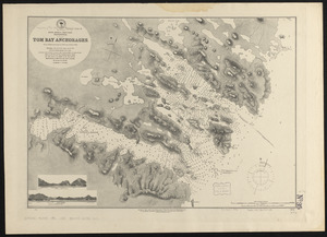
South America-- west coast, Patagonia, Tom Bay anchorages : from British surveys in 1879, corrected to 1882
7515.
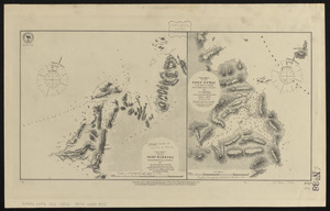
South America, west coast, Port Barbara : from a British survey corrected to 1877 ; South America, west coast, Port Otway in...
7516.
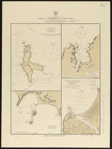
South America, west coast, ports and anchorages on the coast of Chile : special plans to chart no. 752, Santa Maria Id. &...
7517.
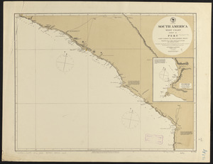
South America, west coast, sheet 10, Bolivia and Peru, C.S. Francisco to Cape Lobos : republication of Brit. Admty. chart no....
7518.
South America, west coast, sheet 11, Peru, Cape Lobos to Pescadores Point : republication of Brit. Admty. chart no. 1283, with...
7519.
South America, west coast, sheet 13, Peru, Independencia Bay to Begueta : republication of Brit. Admty. chart no. 1323 with...
7520.
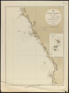
South America, west coast, sheet 15, Peru, Chicama Riv. to Port Payta : republication of Brit. Admty. chart no. 1335, with...
‹ Prev
Next ›
1
2
…
372
373
374
375
376
377
378
379
380
…
437
438