Toggle navigation
LMEC Home
Exhibitions
Georeferencing
Tools for Teachers
Collections
My Favorites
Sign Up / Log In
Search
Search the map portal
Map Collection
Map Collection
Map Sets
Search
Search
Search for
Search In
All Fields
Creator
Title
Subject
Place
Search All Digital Collections
Advanced Search
13 Results
My Search
Start Over
More Like
commonwealth:z603vh20p
Remove constraint More Like: commonwealth:z603vh20p
Topic
Caribbean Area--Maps
Remove constraint Topic: Caribbean Area--Maps
Filter your Search
Place
Caribbean Sea
13
West Indies
13
North and Central America
4
Mesoamerica
3
Mexico, Gulf of
3
Mexico
2
Bermuda
1
Canal Zone
1
more
Place
»
Topic
Caribbean Area--Maps
[remove]
13
West Indies--Maps
13
Mexico, Gulf of--Maps
4
Central America--Maps
3
Mexico--Maps
2
Bermuda Islands--Maps
1
Cables, Submarine--Caribbean Area--Maps
1
Cables, Submarine--West Indies--Maps
1
more
Topic
»
Date
Date range begin
–
Date range end
Current results range from
1758
to
1922
1758 : 1923
1758
1923
View distribution
Creator
American Bank Note Company
1
Bonne, Rigobert, 1727-1794
1
Bowen, Emanuel, -1767
1
Colton, G. Woolworth (George Woolworth), 1827-1901
1
Geo. H. Walker & Co
1
Gibson, J. (John), active 1750-1792
1
Kitchin, Thomas, 1719-1784
1
Lodge, John
1
more
Creator
»
Format
Maps/Atlases
13
Georeferenced
Yes
6
No
7
Collection
Norman B. Leventhal Map & Education Center Collection
7
American Revolutionary War-Era Maps
6
Maps from AAS
6
Maritime Charts and Atlases
1
Available to use
No known restrictions
7
Search Constraints
Sort by relevance
relevance
title
date (asc)
date (desc)
Number of results to display per page
20 per page
10
per page
20
per page
50
per page
100
per page
View results as:
grid view
map view
Search Results
1.
An accurate map of the West Indies, : containing the Bahama & Carribe islands, the Great & Little Antilles, with the Leward and...
2.
An Accurate map of the West Indies, with the adjacent coast
3.
Les Isles Antilles et le Golfe du Méxique
4.
A new and correct map of the American islands, now called the West Indies, : with the whole coast of the neighbouring continent
5.
West Indies
6.
The West Indies, and Gulf of Mexico, : from the latest discoveries and best observations
7.
The countries of the Caribbean : including Mexico, Central America, the West Indies and the Panama Canal
8.
The Evening Post map of the West Indies
9.
Gulf of Mexico, West Indies and Caribbean Sea : from the most recent U.S. Coast Survey, Spanish and British Admiralty charts
10.
Map of Central America, Cuba, Porto Rico, and the islands of the Caribbean Sea
11.
Map of the United States of America, the British Provinces, Mexico, the West Indies and Central America, with part of New...
12.
Map of the West Indies
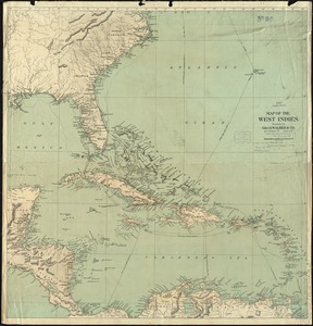
13.
The West India Islands and adjacent territory showing British possessions south of the United States
+
-
Redo search here
Search when I move the map
Leaflet
| ©
OpenStreetMap
contributors, ©
CartoDB