Toggle navigation
LMEC Home
Exhibitions
Georeferencing
Tools for Teachers
Collections
My Favorites
Sign Up / Log In
Search
Search the map portal
Map Collection
Map Collection
Map Sets
Search
Search
Search for
Search In
All Fields
Creator
Title
Subject
Place
Search All Digital Collections
Advanced Search
20 Results
My Search
Start Over
More Like
commonwealth:zs263t266
Remove constraint More Like: commonwealth:zs263t266
Format
Maps/Atlases
Remove constraint Format: Maps/Atlases
Creator
Sayer, Robert, 1725-1794
Remove constraint Creator: Sayer, Robert, 1725-1794
Filter your Search
Place
North and Central America
16
North America
15
Canada
3
United States
3
West Indies
3
Atlantic Ocean
2
Maritime Provinces
2
Saint Lawrence River
2
more
Place
»
Topic
North America--Maps--Early works to 1800
15
West Indies--Maps--Early works to 1800
3
America--Discovery and Exploration--Maps--Early works to 1800
2
Atlantic Ocean--Maps--Early works to 1800
2
United States--History--French and Indian War, 1754-1763--Maps--Early works to 1800
2
Acadia--Maps--Early works to 1800
1
Annapolis Royal (N.S.)--Maps--Early works to 1800
1
Atlantic Ocean--Maps
1
more
Topic
»
Date
Date range begin
–
Date range end
Current results range from
1753
to
1786
1753 : 1787
1753
1787
View distribution
Creator
Sayer, Robert, 1725-1794
[remove]
20
Jefferys, Thomas, -1771
8
Gibson, J. (John), active 1750-1792
4
Anville, Jean Baptiste Bourguignon d', 1697-1782
3
Bowen, Emanuel, 1693 or 1694-1767
3
Green, John, -1757
2
Herbert, William, 1718-1795
2
Society of Anti-Gallicans
2
more
Creator
»
Format
Maps/Atlases
[remove]
20
Georeferenced
Yes
1
No
19
Collection
American Revolutionary War-Era Maps
18
MacLean Collection Map Library
9
Norman B. Leventhal Map & Education Center Collection
5
New York Public Library Collection
3
Richard H. Brown Revolutionary War Map Collection at Mount Vernon
2
Mapping Boston Collection
1
New-York Historical Society Collection
1
Available to use
Creative Commons license
6
No known restrictions
5
Search Constraints
Sort by relevance
relevance
title
date (asc)
date (desc)
Number of results to display per page
20 per page
10
per page
20
per page
50
per page
100
per page
View results as:
grid view
map view
Search Results
1.
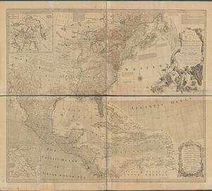
An accurate map of North America describing and distinguishing the British, Spanish and French dominions on this great...
2.
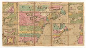
A new and accurate map of the English empire in North America: representing their rightful claim as confirm'd by charters, and...
3.
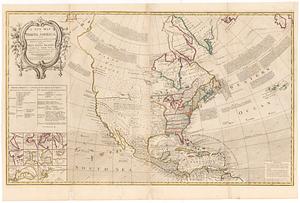
A new map of North America : with the British, French, Spanish, Dutch & Danish dominions on that great continent; and the West...
4.
A new map of North America; with the West India Islands : divided according to the preliminary articles of peace, signed at...
5.
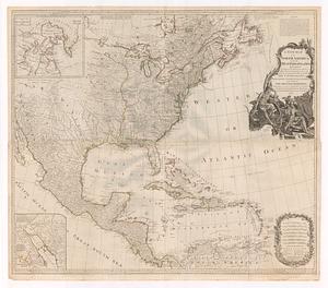
An accurate map of North America : Describing and distinguishing the British and Spanish dominions of this great continent;...
6.
An accurate map of North America : describing and distinguishing the British, Spanish and French dominions on this great...
7.
An accurate map of North America : describing and distinguishing the British and Spanish dominions on this great continent :...
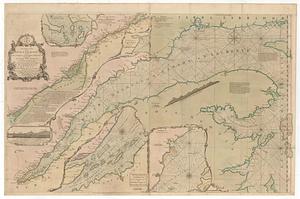
8.
Chart of the Atlantic Ocean, with the British, French, & Spanish settlements in North America, and the West Indies : as also on...
9.
Chart of the Atlantic Ocean, with the British, French, & Spanish settlements in North America, and the West Indies : as also on...
10.
A new and accurate map of the English empire in North America : representing their rightful claim as confirm'd by charters, and...
11.
A new and correct map of North America with the West India Islands : divided according to the last treaty of peace, concluded...
12.
A new map of North America : with the British, French, Spanish, Dutch & Danish dominions on that great continent, and the West...
13.
North America : from the French of Mr. d'Anville, improved with the back settlements of Virginia and course of Ohio,...
14.
North America, as divided amongst the European powers
15.
Theodolite's pattern, shewing the provinces in North America which were in the respective possessions of England, France &...
16.
Carte d'une partie de l'Amérique Septentrionale : pour servir à l'intellegence du mémoire sur les prétentions des anglois au...
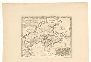
17.
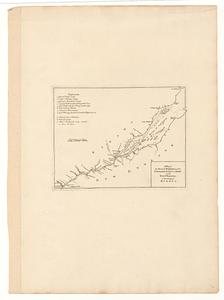
An exact chart of the river S.t Laurence, from Fort Frontenac to the island of Anticosti shewing the soundings, rocks, shoals...
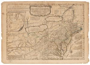
18.
A general map of the Middle British Colonies in America viz. Virginia, Maryland, Delaware, Pensilvania, of Aquanishuonigy the...
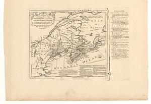
19.
A map, exhibiting a view of the English rights, relative to the ancient limits of Acadia; as supported by express &...
20.
A map of the several dispositions of the English fleet & army on the river S.t Laurence, to the taking of Quebec